191:
38:
156:
98:
176:
UN maps are, in principle, open source material and you can use them in your work or for making your own map. UN requests however that you delete the UN name, logo and reference number upon any modification to the map. Content of your map will be your responsibility. You can state in your
240:
279:
258:
537:
532:
407:
178:
274:
289:
437:
177:
publication, if you wish, something like: based on UN map … (map name, map number, revision number and date). See:
64:
60:
56:
52:
48:
42:
109:
294:
77:
270:
The following pages on the
English Knowledge use this file (pages on other projects are not listed):
170:
Unless stated otherwise, UN maps are to be considered in the public domain. This applies worldwide.
117:
487:
447:
427:
284:
8:
299:
372:
104:
397:
304:
239:
234:
163:
68:
37:
502:
332:
182:
507:
190:
382:
347:
250:
512:
387:
377:
367:
173:
Some UN maps have special copyrights, as indicated on the map itself.
392:
357:
207:
Click on a date/time to view the file as it appeared at that time.
522:
337:
280:
Ecclesiastical provinces and dioceses of the
Episcopal Church
457:
92:
492:
82:(3,277 × 2,433 pixels, file size: 1.92 MB, MIME type:
477:
467:
417:
322:
268:
313:
205:
116:
Commons is a freely licensed media file repository.
97:
183:Geospatial, location data for a better world
14:
428:Frontière entre le Honduras et le Nicaragua
315:The following other wikis use this file:
373:Levantamiento armado en Honduras de 1924
275:Domínguez's expedition to Honduras
155:
128:
398:Guerra civil de Honduras (1831-1832)
150:
503:Conflito armado em Honduras em 1907
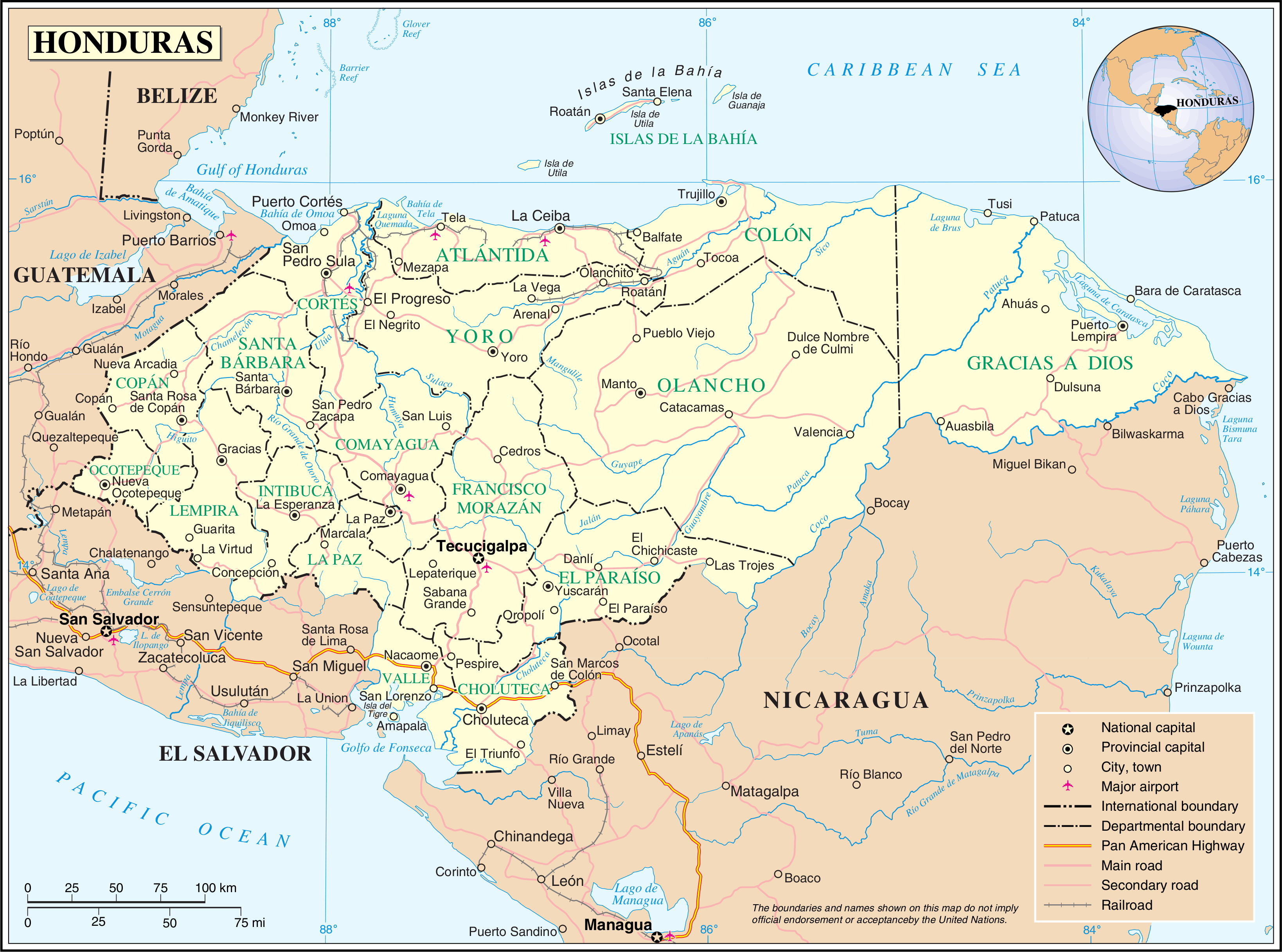
161:This image is a map derived from a
13:
508:Levante militar hondurenho de 1924
333:Index of Honduras-related articles
290:Index of Honduras-related articles
189:
129:
75:
551:
269:
154:
96:
31:
21:
310:
202:
179:Geospatial Information Section
26:
1:
265:
7:
484:Usage on pl.wiktionary.org
434:Usage on gom.wikipedia.org
344:Usage on ast.wikipedia.org
329:Usage on arz.wikipedia.org
295:List of islands of Honduras
10:
556:
529:Usage on uk.wikipedia.org
519:Usage on sl.wikipedia.org
513:Revuelta de las Traiciones
499:Usage on pt.wikipedia.org
474:Usage on nn.wikipedia.org
464:Usage on nl.wikipedia.org
454:Usage on mt.wikipedia.org
444:Usage on mk.wikipedia.org
424:Usage on fr.wikipedia.org
414:Usage on fi.wikipedia.org
404:Usage on fa.wikipedia.org
388:Revuelta de las Traiciones
378:Usuario:Vitrubius32/Taller
364:Usage on es.wikipedia.org
354:Usage on bs.wikipedia.org
319:Usage on af.wikipedia.org
348:Xeografía d'Hondures
259:Category:Maps of Honduras
16:
103:This is a file from the
36:
393:Anexo:Islas de Honduras
383:Hidrografía de Honduras
358:Spisak ostrva Hondurasa
256:
107:. Information from its
235:01:11, 24 October 2007
194:
110:description page there
41:Size of this preview:
368:Geografía de Honduras
285:Geography of Honduras
193:
523:Geografija Hondurasa
69:3,277 × 2,433 pixels
65:2,560 × 1,901 pixels
538:Транспорт Гондурасу
533:Географія Гондурасу
338:Outline of Honduras
300:Outline of Honduras
47:Other resolutions:
195:
61:1,280 × 950 pixels
57:1,024 × 760 pixels
311:Global file usage
263:
199:
198:
149:
148:
125:
124:
105:Wikimedia Commons
32:Global file usage
547:
408:جغرافیای هندوراس
247:
209:
158:
157:
151:
145:
142:
139:
136:
131:
130:
121:
100:
99:
93:
87:
85:
72:
53:640 × 475 pixels
49:320 × 238 pixels
43:800 × 594 pixels
555:
554:
550:
549:
548:
546:
545:
544:
309:
305:Portal:Honduras
271:
264:
253:
245:
201:
200:
143:
140:
137:
134:
127:
126:
115:
114:
113:is shown below.
89:
83:
81:
74:
73:
46:
12:
11:
5:
553:
543:
542:
541:
540:
535:
527:
526:
525:
517:
516:
515:
510:
505:
497:
496:
495:
490:
482:
481:
480:
472:
471:
470:
462:
461:
460:
452:
451:
450:
442:
441:
440:
432:
431:
430:
422:
421:
420:
412:
411:
410:
402:
401:
400:
395:
390:
385:
380:
375:
370:
362:
361:
360:
352:
351:
350:
342:
341:
340:
335:
327:
326:
325:
312:
308:
307:
302:
297:
292:
287:
282:
277:
267:
262:
261:
255:
251:
248:
244:3,277 × 2,433
242:
237:
232:
228:
227:
224:
221:
218:
215:
212:
204:
197:
196:
187:
164:United Nations
159:
147:
146:
123:
122:
101:
91:
90:
40:
35:
34:
29:
24:
19:
9:
6:
4:
3:
2:
552:
539:
536:
534:
531:
530:
528:
524:
521:
520:
518:
514:
511:
509:
506:
504:
501:
500:
498:
494:
491:
489:
486:
485:
483:
479:
476:
475:
473:
469:
466:
465:
463:
459:
456:
455:
453:
449:
446:
445:
443:
439:
436:
435:
433:
429:
426:
425:
423:
419:
416:
415:
413:
409:
406:
405:
403:
399:
396:
394:
391:
389:
386:
384:
381:
379:
376:
374:
371:
369:
366:
365:
363:
359:
356:
355:
353:
349:
346:
345:
343:
339:
336:
334:
331:
330:
328:
324:
321:
320:
318:
317:
316:
306:
303:
301:
298:
296:
293:
291:
288:
286:
283:
281:
278:
276:
273:
272:
260:
257:{{UN map}}
254:
249:
243:
241:
238:
236:
233:
230:
229:
225:
222:
219:
216:
213:
211:
210:
208:
192:
188:
186:
184:
180:
174:
172:
171:
166:
165:
160:
153:
152:
138:Public domain
135:Public domain
133:
132:
119:
112:
111:
106:
102:
95:
94:
88:
79:
78:Original file
70:
66:
62:
58:
54:
50:
44:
39:
33:
30:
28:
25:
23:
20:
18:
15:
314:
206:
203:File history
175:
169:
168:
162:
118:You can help
108:
76:
22:File history
266:File usage
220:Dimensions
27:File usage
246:(1.92 MB)
217:Thumbnail
214:Date/Time
84:image/png
493:Honduras
488:Хондурас
478:Honduras
468:Honduras
458:Ħonduras
448:Хондурас
438:होन्डूरस
418:Honduras
323:Honduras
231:current
226:Comment
181:. And:
80:
252:Jeroen
167:map.
144:false
141:false
223:User
17:File
185:.
67:|
63:|
59:|
55:|
51:|
45:.
120:.
86:)
71:.
Text is available under the Creative Commons Attribution-ShareAlike License. Additional terms may apply.
