298:
43:
305:
455:"}},"text\/plain":{"en":{"":"inception"}}},"{\"value\":{\"time\":\"+2010-02-25T00:00:00Z\",\"timezone\":0,\"before\":0,\"after\":0,\"precision\":11,\"calendarmodel\":\"http:\\\/\\\/www.wikidata.org\\\/entity\\\/Q1985727\"},\"type\":\"time\"}":{"text\/html":{"en":{"P571":"25 February 2010"}},"text\/plain":{"en":{"P571":"25 February 2010"}}}}": -->
312:
261:
99:
411:"}},"text\/plain":{"en":{"":"copyright license"}}},"{\"value\":{\"entity-type\":\"item\",\"numeric-id\":98592850,\"id\":\"Q98592850\"},\"type\":\"wikibase-entityid\"}":{"text\/html":{"en":{"P275":"
367:"}},"text\/plain":{"en":{"":"copyright status"}}},"{\"value\":{\"entity-type\":\"item\",\"numeric-id\":88088423,\"id\":\"Q88088423\"},\"type\":\"wikibase-entityid\"}":{"text\/html":{"en":{"P6216":"
561:
621:
591:
363:
200:
Thracia, Illyria, Moesia, Dacia),Map X,"Comment on Map from author; Map X., & c. - Although most portions of this map are well represented, still we have a deficiency in the classical portion, as it has not been yet sufficiently examined by those who are capable of deciding and systematizing the comparative geography."
148:
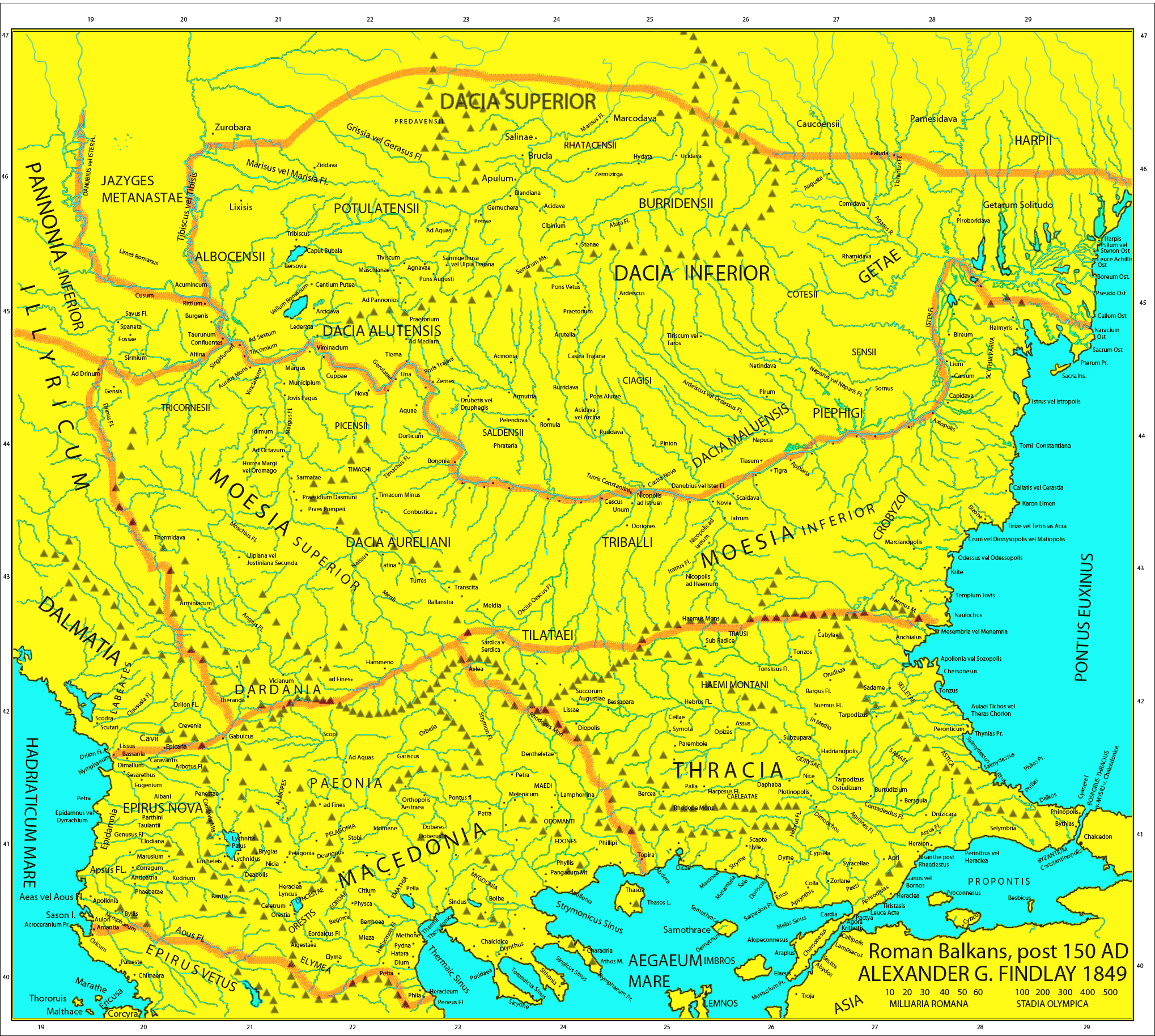
Map of the Roman provinces of
Macedonia, Thracia, Illyricum, part of Pannonia Inferior, Moesia & Dacia. It is a reproduction of the 1849 Finley Map with Roman provincial borders (of about 150 AD) added to provide more information. This means that locations of many cities, tribes or other features
199:
A classical atlas, to illustrate ancient geography: comprised in twenty-five maps, showing the various divisions of the world as known to the ancients : composed from the most authentic sources with an index of the ancient and modern names,Alexander G. Findlay,Publisher;Harper,1849 (Macedonia,
638:== {{int:filedesc}} == {{Information |Description=Map of the Roman provinces of Macedonia, Thracia, Illyricum, part of Pannonia Inferior, Moesia & Dacia. It is a reproduction of the 1849 Finley Map with Roman provincial borders (of about 150 AD) added to
176:
Due to the fact that the 1849 map is damaged, not all the names of some towns and rivers are included. If anyone can discern them add them to the talk page and i will add them to the file
149:
are according to 1849 scholarship and not up to date. For example, many cities shown have not been identified yet and
Findlay made arbirtrary conclusions. A great omission is that
755:
412:
368:
364:
452:
408:
65:
61:
57:
53:
47:
110:
78:
371:"}},"text\/plain":{"en":{"P6216":"copyrighted, dedicated to the public domain by copyright holder"}}}}": -->
662:
571:
541:
415:"}},"text\/plain":{"en":{"P275":"released into the public domain by the copyright holder"}}}}": -->
765:
667:
228:
620:
615:
590:
585:
560:
555:
438:
394:
778:
This file contains additional information, probably added from the digital camera or scanner used to create or digitize it.
378:
462:
422:
353:
781:
If the file has been modified from its original state, some details may not fully reflect the modified file.
530:
525:
69:
42:
297:
601:
648:
The following pages on the
English Knowledge use this file (pages on other projects are not listed):
118:
304:
8:
205:
268:
105:
343:
162:
690:
217:
150:
631:
578:
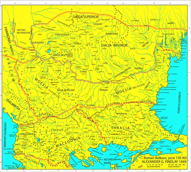
Orthographic correction (alutensis, not alupensis and superior, not superirior)
672:
652:
472:
432:
388:
548:
Regiones
Porolissensis et Napocaoensis cum salinae et aurum excavationes
725:
720:
311:
283:, without any conditions, unless such conditions are required by law.
498:
Click on a date/time to view the file as it appeared at that time.
172:, the atlas was called "classical" and included many types of maps.
657:
266:
I, the copyright holder of this work, release this work into the
395:
copyrighted, dedicated to the public domain by copyright holder
369:
copyrighted, dedicated to the public domain by copyright holder
745:
275:
In some countries this may not be legally possible; if so:
735:
204:
Roman provincial borders are added according to map from
188:
93:
700:
439:
released into the public domain by the copyright holder
413:
released into the public domain by the copyright holder
337:
Add a one-line explanation of what this file represents
646:
681:
496:
117:
Commons is a freely licensed media file repository.
710:
83:(2,038 × 1,828 pixels, file size: 2 MB, MIME type:
663:List of ancient Daco-Thracian peoples and tribes
98:
223:
184:
140:
292:
213:
194:
14:
668:List of ancient tribes in Thrace and Dacia
608:Easier colours for reading the place names
279:I grant anyone the right to use this work
683:The following other wikis use this file:
143:Roman Empire Map AlexanderFindlay1849.png
310:
303:
296:
260:
129:
255:
489:
13:
776:
342:
336:
130:
76:
810:
783:
341:
647:
327:
259:
97:
31:
21:
324:
206:Droysens Historical Atlas, 1886
678:
493:
323:
26:
1:
165:) cities and even later ones.
36:
643:
349:Items portrayed in this file
7:
773:
10:
815:
762:Usage on uk.wikipedia.org
752:Usage on ru.wikipedia.org
742:Usage on ro.wikipedia.org
732:Usage on pt.wikipedia.org
726:Geschiedenis van de Balkan
721:Overleg gebruiker:Jkransen
717:Usage on nl.wikipedia.org
707:Usage on la.wikipedia.org
697:Usage on fr.wikipedia.org
687:Usage on el.wikipedia.org
137:
132:
490:
272:. This applies worldwide.
16:
756:Список фракийских племён
556:14:05, 24 September 2017
326:
104:This is a file from the
41:
637:
616:17:30, 25 February 2010
607:
577:
547:
187:
170:Post-Roman conquest map
157:This map includes even
108:. Information from its
586:20:04, 5 November 2015
315:
308:
301:
111:description page there
46:Size of this preview:
787:Horizontal resolution
603:Spiridon Ion Cepleanu
314:
307:
300:
70:2,038 × 1,828 pixels
66:1,142 × 1,024 pixels
795:Vertical resolution
52:Other resolutions:
316:
309:
302:
802:
801:
679:Global file usage
641:
526:15:44, 5 May 2019
423:copyright license
409:copyright license
335:
320:
319:
288:
287:
276:
254:
253:
232:
229:Reusing this file
126:
125:
106:Wikimedia Commons
32:Global file usage
806:
784:
766:Мезійський лімес
628:
598:
568:
538:
500:
478:25 February 2010
379:copyright status
365:copyright status
333:
274:
263:
262:
256:
250:
247:
244:
241:
236:
235:
226:
190:
189:25 February 2010
144:
138:
122:
101:
100:
94:
88:
86:
73:
62:856 × 768 pixels
58:535 × 480 pixels
54:268 × 240 pixels
48:668 × 599 pixels
814:
813:
809:
808:
807:
805:
804:
803:
772:
677:
649:
642:
634:
626:
604:
596:
574:
566:
544:
536:
492:
491:
488:
487:
486:
485:
484:
483:
482:
481:
479:
469:
468:
467:
465:
450:
449:
448:
447:
446:
445:
444:
443:
441:
429:
428:
427:
425:
406:
405:
404:
403:
402:
401:
400:
399:
397:
385:
384:
383:
381:
362:
361:
360:
359:
358:
356:
340:
339:
338:
321:
281:for any purpose
248:
245:
242:
239:
142:
135:
128:
127:
116:
115:
114:is shown below.
90:
84:
82:
75:
74:
51:
12:
11:
5:
812:
800:
799:
796:
792:
791:
788:
775:
771:
770:
769:
768:
760:
759:
758:
750:
749:
748:
740:
739:
738:
730:
729:
728:
723:
715:
714:
713:
705:
704:
703:
695:
694:
693:
680:
676:
675:
670:
665:
660:
655:
645:
640:
639:
636:
632:
629:
625:2,038 × 1,677
623:
618:
613:
610:
609:
606:
602:
599:
595:2,038 × 1,677
593:
588:
583:
580:
579:
576:
572:
569:
565:2,038 × 1,677
563:
558:
553:
550:
549:
546:
542:
539:
535:2,038 × 1,828
533:
528:
523:
519:
518:
515:
512:
509:
506:
503:
495:
480:
477:
475:
474:
473:
471:
470:
466:
461:
459:
458:
457:
456:
454:
442:
437:
435:
434:
433:
431:
430:
426:
421:
419:
418:
417:
416:
414:
410:
398:
393:
391:
390:
389:
387:
386:
382:
377:
375:
374:
373:
372:
370:
366:
357:
352:
350:
347:
346:
345:
344:
332:
331:
328:
325:
318:
317:
294:
293:Other versions
290:
289:
286:
285:
264:
252:
251:
233:
221:
220:
218:User:Megistias
215:
211:
210:
209:
208:
196:
192:
191:
186:
182:
181:
180:
179:
173:
168:This map is a
166:
159:2nd century AD
145:
136:
134:
131:
124:
123:
102:
92:
91:
45:
40:
39:
34:
29:
24:
19:
9:
6:
4:
3:
2:
811:
797:
794:
793:
789:
786:
785:
782:
779:
767:
764:
763:
761:
757:
754:
753:
751:
747:
746:Marcianopolis
744:
743:
741:
737:
734:
733:
731:
727:
724:
722:
719:
718:
716:
712:
709:
708:
706:
702:
699:
698:
696:
692:
689:
688:
686:
685:
684:
674:
673:Moesian Limes
671:
669:
666:
664:
661:
659:
656:
654:
651:
650:
635:
630:
624:
622:
619:
617:
614:
612:
611:
605:
600:
594:
592:
589:
587:
584:
582:
581:
575:
570:
564:
562:
559:
557:
554:
552:
551:
545:
540:
534:
532:
529:
527:
524:
521:
520:
516:
513:
510:
507:
504:
502:
501:
499:
476:
464:
460:
440:
436:
424:
420:
396:
392:
380:
376:
355:
351:
348:
329:
322:
313:
306:
299:
295:
291:
284:
282:
277:
273:
271:
270:
269:public domain
265:
258:
257:
243:Public domain
240:Public domain
238:
237:
234:
230:
225:
222:
219:
216:
212:
207:
203:
202:
201:
197:
193:
183:
177:
174:
171:
167:
164:
160:
156:
155:
154:
153:are missing.
152:
146:
139:
120:
113:
112:
107:
103:
96:
95:
89:
80:
79:Original file
71:
67:
63:
59:
55:
49:
44:
38:
35:
33:
30:
28:
25:
23:
20:
18:
15:
780:
777:
682:
653:Burs (Dacia)
497:
494:File history
280:
278:
267:
198:
175:
169:
163:Adrianopolis
158:
151:Lake Prespas
147:
119:You can help
109:
77:
22:File history
141:Description
644:File usage
511:Dimensions
224:Permission
27:File usage
798:78.74 dpc
790:78.74 dpc
633:Megistias
573:Julieta39
543:Julieta39
508:Thumbnail
505:Date/Time
463:inception
453:inception
85:image/png
774:Metadata
627:(1.8 MB)
597:(1.9 MB)
567:(1.9 MB)
330:Captions
37:Metadata
736:Jáziges
658:Dacians
522:current
517:Comment
354:depicts
334:English
133:Summary
81:
711:Moesia
691:Μοισία
537:(2 MB)
214:Author
195:Source
161:(i.e.
701:Mésie
249:false
246:false
514:User
185:Date
17:File
68:|
64:|
60:|
56:|
50:.
231:)
227:(
178:.
121:.
87:)
72:.


