257:
528:"}},"text\/plain":{"en":{"":"inception"}}},"{\"value\":{\"time\":\"+2005-02-01T00:00:00Z\",\"timezone\":0,\"before\":0,\"after\":0,\"precision\":10,\"calendarmodel\":\"http:\\\/\\\/www.wikidata.org\\\/entity\\\/Q1985727\"},\"type\":\"time\"}":{"text\/html":{"en":{"P571":"February 2005"}},"text\/plain":{"en":{"P571":"February 2005"}}}}": -->
38:
193:
301:
86:
440:"}},"text\/plain":{"en":{"":"copyright license"}}},"{\"value\":{\"entity-type\":\"item\",\"numeric-id\":98592850,\"id\":\"Q98592850\"},\"type\":\"wikibase-entityid\"}":{"text\/html":{"en":{"P275":"
396:"}},"text\/plain":{"en":{"":"copyright status"}}},"{\"value\":{\"entity-type\":\"item\",\"numeric-id\":88088423,\"id\":\"Q88088423\"},\"type\":\"wikibase-entityid\"}":{"text\/html":{"en":{"P6216":"
480:
348:
This map is published by the Kansas
Department of Transportation and is distributed to the public free of charge. KDOT makes no warranties, guarantees, or representations for accuracy of this information and assumes no liability for errors or omissions. Maps produced using tax payer dollars are
484:"}},"text\/plain":{"en":{"":"Wikimedia VRTS ticket number"}}},"{\"value\":\"2013040310012673\",\"type\":\"string\"}":{"text\/html":{"en":{"P6305":"
256:
485:
197:
215:
The
Wikimedia Foundation has received an e-mail confirming that the copyright holder has approved publication under the terms mentioned on this page. This correspondence has been
441:
397:
481:
393:
718:
525:
437:
400:"}},"text\/plain":{"en":{"P6216":"copyrighted, dedicated to the public domain by copyright holder"}}}}": -->
160:
231:
511:
444:"}},"text\/plain":{"en":{"P275":"released into the public domain by the copyright holder"}}}}": -->
52:
48:
42:
240:
708:
209:
180:
65:
97:
698:
467:
423:
495:
407:
703:
693:
247:
748:
535:
451:
382:
226:
222:
213:, you do not need to request permission as long as you follow any licensing requirements mentioned on this page.
488:"}},"text\/plain":{"en":{"P6305":"2013040310012673"}}}}": -->
631:
The following pages on the
English Knowledge use this file (pages on other projects are not listed):
248:
https://ticket.wikimedia.org/otrs/index.pl?Action=AgentTicketZoom&TicketNumber=2013040310012673
603:
598:
56:
37:
105:
135:
670:
645:
204:
8:
650:
308:
92:
372:
675:
660:
138:, USA, is copied at a resolution of 300 pixels/inch from the original PDF file.
665:
655:
640:
614:
323:
Kansas
Department of Transportation grants anyone the right to use this work
635:
545:
505:
461:
417:
239:
If you have questions about the archived correspondence, please use the
327:, without any conditions, unless such conditions are required by law.
571:
Click on a date/time to view the file as it appeared at that time.
738:
171:
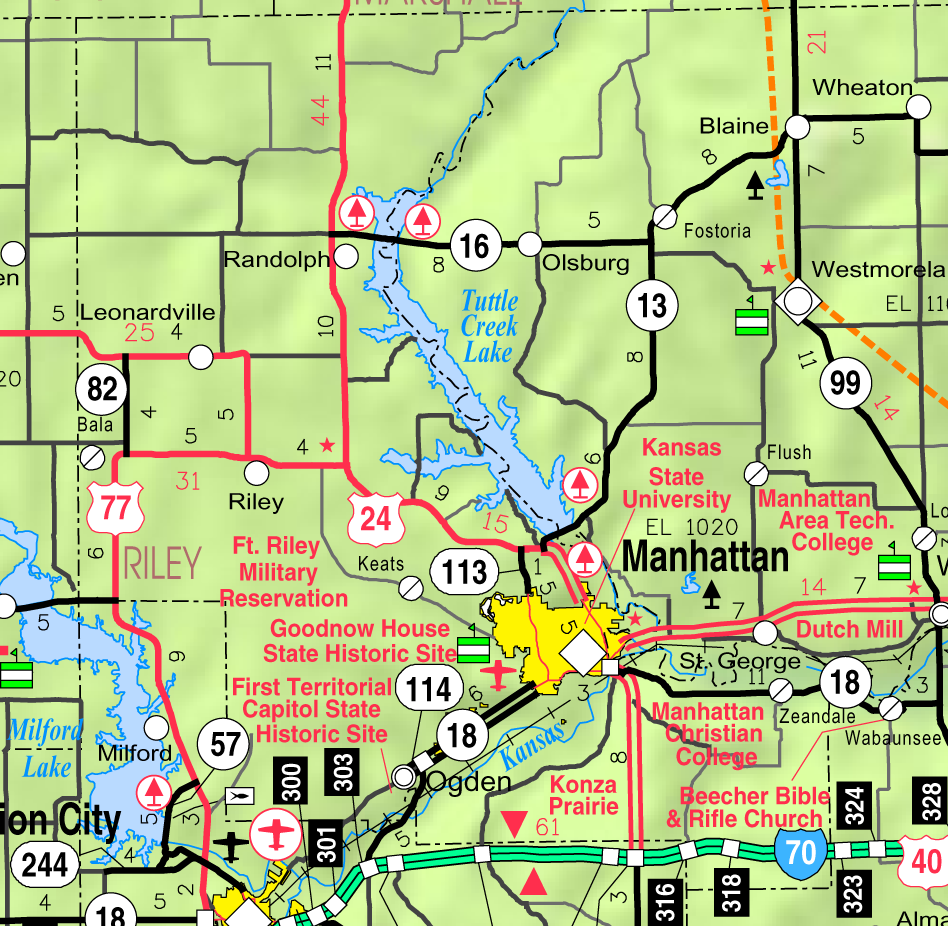
Designed and published by the Kansas
Department of Transportation.
157:
758:
424:
copyrighted, dedicated to the public domain by copyright holder
398:
copyrighted, dedicated to the public domain by copyright holder
621:
229:. The correspondence is available to trusted volunteers as
319:
In some countries this may not be legally possible; if so:
207:
and may be used by anyone for any purpose. If you wish to
728:
80:
468:
released into the public domain by the copyright holder
442:
released into the public domain by the copyright holder
366:
Add a one-line explanation of what this file represents
146:
629:
684:
569:
104:
Commons is a freely licensed media file repository.
70:(948 × 926 pixels, file size: 467 KB, MIME type:
85:
175:
156:Kansas 2005–2006 Official Transportation Map
142:
127:
167:
152:
14:
686:The following other wikis use this file:
253:Find other files from the same ticket:
306:This work has been released into the
300:
192:
116:
295:
223:Volunteer Response Team (VRT) member
187:
562:
314:Kansas Department of Transportation
217:
13:
371:
365:
117:
63:
772:
370:
630:
356:
299:
255:
191:
84:
31:
21:
353:
735:Usage on simple.wikipedia.org
681:
566:
352:
26:
1:
626:
496:Wikimedia VRTS ticket number
482:Wikimedia VRTS ticket number
378:Items portrayed in this file
271:
130:Map of Riley Co, Ks, USA.png
7:
690:Usage on azb.wikipedia.org
10:
777:
755:Usage on zh.wikipedia.org
745:Usage on ur.wikipedia.org
725:Usage on nl.wikipedia.org
715:Usage on mr.wikipedia.org
124:
119:
563:
316:. This applies worldwide.
16:
355:
232:ticket #2013040310012673
190:
91:This is a file from the
36:
620:
145:
95:. Information from its
98:description page there
41:Size of this preview:
349:free for public use.
671:Riley County, Kansas
646:Leonardville, Kansas
136:Riley County, Kansas
599:16:05, 10 June 2006
47:Other resolutions:
227:permission archive
225:and stored in our
739:Manhattan, Kansas
682:Global file usage
651:Manhattan, Kansas
624:
452:copyright license
438:copyright license
364:
346:
345:
320:
294:
293:
268:
267:
264:
263:
254:
250:
244:
184:
181:Reusing this file
113:
112:
93:Wikimedia Commons
32:Global file usage
768:
719:मॅनहॅटन (कॅन्सस)
709:مانهاتان، کانزاس
676:Zeandale, Kansas
661:Randolph, Kansas
611:
573:
512:2013040310012673
486:2013040310012673
408:copyright status
394:copyright status
362:
341:
338:
335:
332:
318:
303:
302:
296:
290:
287:
284:
281:
276:
275:
259:
252:
245:
238:
219:
210:use this content
199:
195:
194:
188:
178:
148:
131:
125:
109:
88:
87:
81:
75:
73:
60:
57:948 × 926 pixels
53:491 × 480 pixels
49:246 × 240 pixels
43:614 × 600 pixels
776:
775:
771:
770:
769:
767:
766:
765:
699:راندولف، کانزاس
680:
632:
625:
617:
609:
565:
564:
561:
560:
559:
558:
557:
556:
555:
554:
552:
542:
541:
540:
538:
523:
522:
521:
520:
519:
518:
517:
516:
514:
502:
501:
500:
498:
479:
478:
477:
476:
475:
474:
473:
472:
470:
458:
457:
456:
454:
435:
434:
433:
432:
431:
430:
429:
428:
426:
414:
413:
412:
410:
391:
390:
389:
388:
387:
385:
369:
368:
367:
339:
336:
333:
330:
325:for any purpose
312:by its author,
288:
285:
282:
279:
274:
269:
241:VRT noticeboard
129:
122:
115:
114:
103:
102:
101:is shown below.
77:
71:
69:
62:
61:
46:
12:
11:
5:
774:
764:
763:
762:
761:
753:
752:
751:
743:
742:
741:
733:
732:
731:
723:
722:
721:
713:
712:
711:
706:
701:
696:
683:
679:
678:
673:
668:
663:
658:
653:
648:
643:
638:
628:
623:
622:
619:
615:
612:
606:
601:
596:
592:
591:
588:
585:
582:
579:
576:
568:
553:
550:
548:
547:
546:
544:
543:
539:
534:
532:
531:
530:
529:
527:
515:
510:
508:
507:
506:
504:
503:
499:
494:
492:
491:
490:
489:
487:
483:
471:
466:
464:
463:
462:
460:
459:
455:
450:
448:
447:
446:
445:
443:
439:
427:
422:
420:
419:
418:
416:
415:
411:
406:
404:
403:
402:
401:
399:
395:
386:
381:
379:
376:
375:
374:
373:
361:
360:
357:
354:
344:
343:
304:
292:
291:
273:
270:
266:
265:
262:
261:
201:
185:
173:
172:
169:
165:
164:
154:
150:
149:
144:
140:
139:
132:
123:
121:
118:
111:
110:
89:
79:
78:
40:
35:
34:
29:
24:
19:
9:
6:
4:
3:
2:
773:
760:
757:
756:
754:
750:
749:مینہٹن، کنساس
747:
746:
744:
740:
737:
736:
734:
730:
727:
726:
724:
720:
717:
716:
714:
710:
707:
705:
704:رایلی، کانزاس
702:
700:
697:
695:
694:اوقدن، کانزاس
692:
691:
689:
688:
687:
677:
674:
672:
669:
667:
666:Riley, Kansas
664:
662:
659:
657:
656:Ogden, Kansas
654:
652:
649:
647:
644:
642:
641:Keats, Kansas
639:
637:
634:
633:
618:
613:
607:
605:
602:
600:
597:
594:
593:
589:
586:
583:
580:
577:
575:
574:
572:
551:February 2005
549:
537:
533:
513:
509:
497:
493:
469:
465:
453:
449:
425:
421:
409:
405:
384:
380:
377:
358:
351:
350:
342:
334:Public domain
331:Public domain
328:
326:
321:
317:
315:
311:
310:
309:public domain
305:
298:
297:
283:Public domain
280:Public domain
278:
277:
260:
258:
251:
249:
246:Ticket link:
242:
236:
234:
233:
228:
224:
220:
212:
211:
206:
203:This work is
202:
200:
189:
186:
182:
177:
174:
170:
166:
162:
158:
155:
151:
147:February 2005
141:
137:
133:
126:
107:
100:
99:
94:
90:
83:
82:
76:
67:
66:Original file
58:
54:
50:
44:
39:
33:
30:
28:
25:
23:
20:
18:
15:
729:Riley County
685:
636:Bala, Kansas
570:
567:File history
347:
329:
324:
322:
313:
307:
237:
230:
216:
214:
208:
196:
134:This map of
106:You can help
96:
64:
22:File history
128:Description
627:File usage
608:948 × 926
584:Dimensions
176:Permission
161:map legend
27:File usage
581:Thumbnail
578:Date/Time
536:inception
526:inception
272:Licensing
72:image/png
616:Moverton
610:(467 KB)
359:Captions
218:reviewed
595:current
590:Comment
383:depicts
363:English
120:Summary
68:
198:
168:Author
153:Source
340:false
337:false
289:false
286:false
221:by a
587:User
205:free
143:Date
17:File
759:賴利
235:.
55:|
51:|
45:.
243:.
183:)
179:(
163:)
159:(
108:.
74:)
59:.