209:
556:"}},"text\/plain":{"en":{"":"inception"}}},"{\"value\":{\"time\":\"+2012-05-01T00:00:00Z\",\"timezone\":0,\"before\":0,\"after\":0,\"precision\":10,\"calendarmodel\":\"http:\\\/\\\/www.wikidata.org\\\/entity\\\/Q1985727\"},\"type\":\"time\"}":{"text\/html":{"en":{"P571":"May 2012"}},"text\/plain":{"en":{"P571":"May 2012"}}}}": -->
353:
359:
279:
91:
43:
512:"}},"text\/plain":{"en":{"":"copyright license"}}},"{\"value\":{\"entity-type\":\"item\",\"numeric-id\":19125117,\"id\":\"Q19125117\"},\"type\":\"wikibase-entityid\"}":{"text\/html":{"en":{"P275":"
468:"}},"text\/plain":{"en":{"":"copyright status"}}},"{\"value\":{\"entity-type\":\"item\",\"numeric-id\":50423863,\"id\":\"Q50423863\"},\"type\":\"wikibase-entityid\"}":{"text\/html":{"en":{"P6216":"
464:
400:– You must give appropriate credit, provide a link to the license, and indicate if changes were made. You may do so in any reasonable manner, but not in any way that suggests the licensor endorses you or your use.
513:
469:
465:
553:
509:
642:
305:
for more information. If an SVG form of this image is available, please upload it and afterwards replace this template with
57:
53:
47:
102:
70:
238:(note that commune boundaries are also available under free license at geofla, but not near acceptable quality due to extreme simplification!)
196:
302:
680:
256:
516:"}},"text\/plain":{"en":{"P275":"Creative Commons Attribution 2.0 Generic"}}}}": -->
539:
495:
843:
This file contains additional information, probably added from the digital camera or scanner used to create or digitize it.
479:
322:
308:
563:
523:
454:
247:
846:
If the file has been modified from its original state, some details may not fully reflect the modified file.
208:
369:
221:
662:
631:
626:
472:"}},"text\/plain":{"en":{"P6216":"copyrighted"}}}}": -->
296:
61:
42:
658:
The following pages on the
English Knowledge use this file (pages on other projects are not listed):
225:
217:
110:
235:
321:
It is recommended to name the SVG file “Map commune FR insee code 78146.svg”—then the template
366:
8:
251:• Mentioned sources combined and exported for each commune using a script by Michiel1972
97:
444:
292:
200:
326:
573:
533:
489:
241:
730:
800:
599:
Click on a date/time to view the file as it appeared at that time.
240:• Data for exact commune* and department boundaries: derived via
760:
229:
830:
820:
85:
438:
Add a one-line explanation of what this file represents
170:
656:
810:
671:
597:
109:
Commons is a freely licensed media file repository.
790:
780:
770:
750:
740:
720:
710:
700:
690:
246:• Data for landuse: OSM / Corine land cover, 2006 (
75:(756 × 605 pixels, file size: 66 KB, MIME type:
90:
352:
166:
132:
269:
184:
176:
14:
407:https://creativecommons.org/licenses/by/2.0
383:– to copy, distribute and transmit the work
244:and osm2pgsql, OpenStreetMap contributors.
673:The following other wikis use this file:
255:*note: shown commune boundaries are from
540:Creative Commons Attribution 2.0 Generic
514:Creative Commons Attribution 2.0 Generic
301:. This has several advantages; see
234:• Label and Insee code commune: from
121:
273:
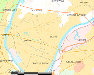
153:Carte des communes françaises Chatou
590:
358:
135:Map commune FR insee code 78146.png
13:
841:
817:Usage on zh-min-nan.wikipedia.org
443:
437:
374:
349:
284:
232:contributors. Status december 2011
207:
155:
147:
139:
122:
68:
875:
848:
442:
413:Creative Commons Attribution 2.0
259:; at that time about 90% complete
145:Map of French municipality Chatou
657:
428:
394:Under the following conditions:
365:This file is licensed under the
357:
351:
277:
188:
180:derived work, see author details
161:Kaart van Franse gemeente Chatou
89:
31:
21:
425:
140:
668:
594:
424:
216:• Shape files infrastructure:
148:
26:
1:
156:
36:
653:
450:Items portrayed in this file
345:
199:OpenStreetMap contributors,
7:
838:
757:Usage on mzn.wikipedia.org
10:
880:
827:Usage on zh.wikipedia.org
807:Usage on www.wikidata.org
797:Usage on tt.wikipedia.org
787:Usage on sv.wikipedia.org
777:Usage on ro.wikipedia.org
767:Usage on pt.wikipedia.org
747:Usage on la.wikipedia.org
737:Usage on id.wikipedia.org
727:Usage on fr.wikipedia.org
717:Usage on eu.wikipedia.org
707:Usage on es.wikipedia.org
697:Usage on eo.wikipedia.org
687:Usage on ca.wikipedia.org
677:Usage on ar.wikipedia.org
289:image could be re-created
129:
124:
731:Pays des Impressionnistes
663:Pays des Impressionnistes
591:
303:Commons:Media for cleanup
242:osm download geofabrik.de
16:
427:
323:Vector version available
309:vector version available
96:This is a file from the
41:
648:
370:Attribution 2.0 Generic
169:
100:. Information from its
213:
103:description page there
46:Size of this preview:
852:Horizontal resolution
211:
329:) does not need the
228:: all originally by
860:Vertical resolution
681:شاتو (إيل دو فرانس)
389:– to adapt the work
52:Other resolutions:
627:17:26, 8 June 2012
214:
867:
866:
669:Global file usage
651:
524:copyright license
510:copyright license
436:
342:
341:
338:
337:
265:
264:
260:
257:OSM dump May 2012
118:
117:
98:Wikimedia Commons
32:Global file usage
871:
849:
644:RobotMichiel1972
639:
601:
480:copyright status
466:copyright status
434:
420:
417:
414:
411:
408:
367:Creative Commons
361:
360:
355:
354:
316:
281:
280:
274:
254:
189:
172:
160:
152:
150:Français :
144:
136:
130:
114:
93:
92:
86:
80:
78:
65:
62:756 × 605 pixels
58:600 × 480 pixels
54:300 × 240 pixels
48:749 × 599 pixels
879:
878:
874:
873:
872:
870:
869:
868:
837:
667:
659:
652:
645:
637:
593:
592:
589:
588:
587:
586:
585:
584:
583:
582:
580:
570:
569:
568:
566:
551:
550:
549:
548:
547:
546:
545:
544:
542:
530:
529:
528:
526:
507:
506:
505:
504:
503:
502:
501:
500:
498:
486:
485:
484:
482:
463:
462:
461:
460:
459:
457:
441:
440:
439:
422:
421:
418:
415:
412:
409:
406:
405:
373:
362:
348:
343:
334:
306:
293:vector graphics
278:
204:
162:
154:
146:
134:
127:
120:
119:
108:
107:
106:is shown below.
82:
76:
74:
67:
66:
51:
12:
11:
5:
877:
865:
864:
861:
857:
856:
853:
840:
836:
835:
834:
833:
825:
824:
823:
815:
814:
813:
805:
804:
803:
795:
794:
793:
785:
784:
783:
775:
774:
773:
765:
764:
763:
755:
754:
753:
745:
744:
743:
735:
734:
733:
725:
724:
723:
715:
714:
713:
705:
704:
703:
695:
694:
693:
685:
684:
683:
670:
666:
665:
655:
650:
649:
647:
643:
640:
634:
629:
624:
620:
619:
616:
613:
610:
607:
604:
596:
581:
578:
576:
575:
574:
572:
571:
567:
562:
560:
559:
558:
557:
555:
543:
538:
536:
535:
534:
532:
531:
527:
522:
520:
519:
518:
517:
515:
511:
499:
494:
492:
491:
490:
488:
487:
483:
478:
476:
475:
474:
473:
471:
467:
458:
453:
451:
448:
447:
446:
445:
433:
432:
429:
426:
404:
403:
402:
401:
392:
391:
390:
384:
377:You are free:
364:
363:
350:
347:
344:
340:
339:
336:
335:
331:new image name
313:new image name
282:
271:
270:Other versions
267:
266:
263:
262:
193:
186:
182:
181:
178:
174:
173:
168:
164:
163:
137:
128:
126:
123:
116:
115:
94:
84:
83:
45:
40:
39:
34:
29:
24:
19:
9:
6:
4:
3:
2:
876:
862:
859:
858:
854:
851:
850:
847:
844:
832:
829:
828:
826:
822:
819:
818:
816:
812:
809:
808:
806:
802:
799:
798:
796:
792:
789:
788:
786:
782:
779:
778:
776:
772:
769:
768:
766:
762:
759:
758:
756:
752:
749:
748:
746:
742:
739:
738:
736:
732:
729:
728:
726:
722:
719:
718:
716:
712:
709:
708:
706:
702:
699:
698:
696:
692:
689:
688:
686:
682:
679:
678:
676:
675:
674:
664:
661:
660:
646:
641:
635:
633:
630:
628:
625:
622:
621:
617:
614:
611:
608:
605:
603:
602:
600:
577:
565:
561:
541:
537:
525:
521:
497:
493:
481:
477:
456:
452:
449:
430:
423:
399:
396:
395:
393:
388:
385:
382:
379:
378:
376:
375:
371:
368:
356:
332:
328:
324:
320:
319:
314:
310:
304:
300:
298:
294:
288:
283:
276:
275:
272:
268:
261:
258:
252:
250:
248:
245:
243:
239:
237:
233:
231:
230:OpenStreetMap
227:
223:
219:
210:
206:
205:
203:
202:
198:
191:
190:
187:
183:
179:
175:
165:
159:
151:
143:
138:
131:
112:
105:
104:
99:
95:
88:
87:
81:
72:
71:Original file
63:
59:
55:
49:
44:
38:
35:
33:
30:
28:
25:
23:
20:
18:
15:
845:
842:
672:
598:
595:File history
397:
386:
380:
330:
318:
312:
290:
286:
253:
215:
194:
192:
158:Nederlands:
157:
149:
141:
111:You can help
101:
69:
22:File history
496:copyrighted
470:copyrighted
398:attribution
133:Description
654:File usage
636:756 × 605
612:Dimensions
410:CC BY 2.0
333:parameter.
27:File usage
609:Thumbnail
606:Date/Time
564:inception
554:inception
346:Licensing
195:Map data
142:English:
77:image/png
863:37.8 dpc
855:37.8 dpc
839:Metadata
579:May 2012
431:Captions
387:to remix
381:to share
372:license.
222:highways
201:CC-BY-SA
171:May 2012
37:Metadata
811:Q240752
638:(66 KB)
623:current
618:Comment
455:depicts
435:English
218:railway
125:Summary
73:
821:Chatou
791:Chatou
781:Chatou
771:Chatou
751:Chatou
741:Chatou
721:Chatou
711:Chatou
701:Chatou
691:Chatou
295:as an
291:using
236:Geofla
212:Legend
185:Author
177:Source
285:This
226:water
801:Шату
615:User
419:true
416:true
325:(or
299:file
167:Date
17:File
761:شتو
327:Vva
297:SVG
287:map
197:(c)
831:沙图
315:}}
307:{{
224:,
220:,
60:|
56:|
50:.
317:.
311:|
249:)
113:.
79:)
64:.
Text is available under the Creative Commons Attribution-ShareAlike License. Additional terms may apply.

_French_municipality_map.svg)