371:"}},"text\/plain":{"en":{"":"inception"}}},"{\"value\":{\"time\":\"+1934-07-11T00:00:00Z\",\"timezone\":0,\"before\":0,\"after\":0,\"precision\":11,\"calendarmodel\":\"http:\\\/\\\/www.wikidata.org\\\/entity\\\/Q1985727\"},\"type\":\"time\"}":{"text\/html":{"en":{"P571":"11 July 1934"}},"text\/plain":{"en":{"P571":"11 July 1934"}}}}": -->
312:
38:
189:
86:
409:"}},"text\/plain":{"en":{"":"media type"}}},"{\"value\":\"image\\\/jpeg\",\"type\":\"string\"}":{"text\/html":{"en":{"P1163":"image\/jpeg"}},"text\/plain":{"en":{"P1163":"image\/jpeg"}}}}": -->
405:
278:
of the data may not be done in a way which suggests that the Danish
Geodata Agency endorses, supports, recommends or markets the user of the data, or the services or products of the user of the data, and re-users must ensure the use of the data is in accordance with Danish
502:
Uploaded a work by
Geodetic Institute Copenahagen & Reykjavík 1934 from https://myndir.islandskort.is/map/Uppdrattur_Islands___1_1_________1921_1944_38/21__Drangajokull_751/1016/2012-10-16-12-32-24.jpg with
406:
368:
159:
495:
209:
No date for retrieval has been added! A date must be added for this license tag to be valid, otherwise the file must be tagged with {{subst:
160:
https://myndir.islandskort.is/map/Uppdrattur_Islands___1_1_________1921_1944_38/21__Drangajokull_751/1016/2012-10-16-12-32-24.jpg
416:
378:
357:
291:
233:
52:
48:
42:
221:
No source set has been provided! The source set must be provided, otherwise the file must be tagged with {{subst:
97:
65:
513:
The following pages on the
English Knowledge use this file (pages on other projects are not listed):
105:
8:
264:
Further if other sourced are mentioned on the front of a service re-using these data,
92:
484:
479:
347:
56:
37:
292:
https://sdfe.dk/media/2916594/vilkaar-for-brug-af-frie-geografiske-data_2016.pdf
259:
the date when the set(s) of data were retrieved from the Danish
Geodata Agency.
222:
210:
426:
388:
195:
The contents of this file is, in either full extent or partially, based on
517:
452:
Click on a date/time to view the file as it appeared at that time.
286:
must be made available for third parties, possibly using a link.
535:
232:
Open public geographic data may be freely reused under the
149:
80:
511:
526:
450:
256:
the name(s) of the set(s) of data that was used, and
183:
104:
Commons is a freely licensed media file repository.
169:
Geodetic
Institute Copenahagen & Reykjavík 1934
70:(1,878 × 739 pixels, file size: 595 KB, MIME type:
322:
85:
145:
127:
247:Contains data from the Danish Geodata Agency
165:
155:
14:
528:The following other wikis use this file:
236:for use of open public geographic data:
116:
251:Indeholder data fra Geodatastyrelsen
181:the copyright has certainly expired
443:
13:
346:
340:
310:
134:
117:
63:
549:
345:
512:
331:
187:
84:
31:
21:
328:
135:
523:
447:
327:
26:
1:
508:
353:Items portrayed in this file
176:
7:
197:open public geographic data
10:
554:
532:Usage on is.wikipedia.org
124:
119:
444:
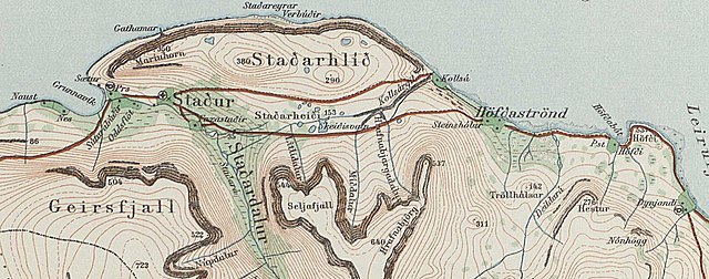
341:Grunnavík & Maríuhorn
299:Danish Geodata Agency map
16:
330:
91:This is a file from the
36:
501:
148:
95:. Information from its
315:
284:copy of the conditions
98:description page there
41:Size of this preview:
314:
272:must appear likewise.
266:Danish Geodata Agency
201:Danish Geodata Agency
480:00:40, 5 April 2021
243:include as follow:
47:Other resolutions:
316:
57:1,878 × 739 pixels
524:Global file usage
506:
339:
320:
319:
173:
172:
113:
112:
93:Wikimedia Commons
32:Global file usage
545:
492:
454:
337:
324:
313:
306:
303:
300:
297:
294:
270:Geodatastyrelsen
241:Attribution must
227:
215:
191:
190:
184:
151:
139:
131:
125:
109:
88:
87:
81:
75:
73:
60:
53:640 × 252 pixels
49:320 × 126 pixels
43:800 × 315 pixels
553:
552:
548:
547:
546:
544:
543:
542:
522:
514:
507:
498:
490:
446:
445:
442:
441:
440:
439:
438:
437:
436:
435:
433:
423:
422:
421:
419:
404:
403:
402:
401:
400:
399:
398:
397:
395:
385:
384:
383:
381:
366:
365:
364:
363:
362:
360:
344:
343:
342:
311:
304:
301:
298:
295:
290:
219:
207:
188:
179:
174:
141:
129:
122:
115:
114:
103:
102:
101:is shown below.
77:
71:
69:
62:
61:
46:
12:
11:
5:
551:
541:
540:
539:
538:
525:
521:
520:
510:
505:
504:
500:
496:
493:
487:
482:
477:
473:
472:
469:
466:
463:
460:
457:
449:
434:
431:
429:
428:
427:
425:
424:
420:
415:
413:
412:
411:
410:
408:
396:
393:
391:
390:
389:
387:
386:
382:
377:
375:
374:
373:
372:
370:
361:
356:
354:
351:
350:
349:
348:
336:
335:
332:
329:
318:
317:
308:
288:
287:
280:
273:
262:
261:
260:
257:
254:
229:
228:
217:
192:
178:
175:
171:
170:
167:
163:
162:
157:
153:
152:
147:
143:
142:
132:
123:
121:
118:
111:
110:
89:
79:
78:
40:
35:
34:
29:
24:
19:
9:
6:
4:
3:
2:
550:
537:
534:
533:
531:
530:
529:
519:
516:
515:
499:
494:
488:
486:
483:
481:
478:
475:
474:
470:
467:
464:
461:
458:
456:
455:
453:
430:
418:
414:
392:
380:
376:
359:
355:
352:
333:
326:
325:
309:
307:
293:
285:
281:
277:
274:
271:
267:
263:
258:
255:
252:
248:
245:
244:
242:
239:
238:
237:
235:
231:
226:
224:
218:
214:
212:
206:
205:
204:
202:
198:
193:
186:
185:
182:
168:
164:
161:
158:
154:
144:
138:
133:
130:Grunnavík.jpg
126:
107:
100:
99:
94:
90:
83:
82:
76:
67:
66:Original file
58:
54:
50:
44:
39:
33:
30:
28:
25:
23:
20:
18:
15:
527:
503:UploadWizard
489:1,878 × 739
451:
448:File history
394:11 July 1934
321:
289:
283:
275:
269:
265:
250:
246:
240:
230:
220:
208:
200:
196:
194:
180:
150:11 July 1934
136:
106:You can help
96:
64:
22:File history
128:Description
509:File usage
465:Dimensions
432:image/jpeg
417:media type
407:media type
234:conditions
72:image/jpeg
27:File usage
536:Grunnavík
518:Grunnavík
462:Thumbnail
459:Date/Time
379:inception
369:inception
199:from the
177:Licensing
140:Grunnavík
137:English:
491:(595 KB)
334:Captions
476:current
471:Comment
358:depicts
338:English
296:DGA map
120:Summary
68:
497:Xypete
323:
166:Author
156:Source
302:false
276:Usage
253:, and
468:User
305:true
279:law.
146:Date
17:File
268:or
249:or
225:}}.
223:npd
211:npd
282:A
213:}}
55:|
51:|
45:.
216:.
203::
108:.
74:)
59:.
