38:
898:"}},"text\/plain":{"en":{"":"checksum"}}},"{\"value\":\"866d3f98cad127ada40fb0baaa15f49c5cf432f8\",\"type\":\"string\"}":{"text\/html":{"en":{"P4092":"866d3f98cad127ada40fb0baaa15f49c5cf432f8"}},"text\/plain":{"en":{"P4092":"866d3f98cad127ada40fb0baaa15f49c5cf432f8"}}},"{\"value\":{\"entity-type\":\"property\",\"numeric-id\":459,\"id\":\"P459\"},\"type\":\"wikibase-entityid\"}":{"text\/html":{"en":{"":"
234:
716:
1138:
98:
637:
902:"}},"text\/plain":{"en":{"":"determination method"}}},"{\"value\":{\"entity-type\":\"item\",\"numeric-id\":13414952,\"id\":\"Q13414952\"},\"type\":\"wikibase-entityid\"}":{"text\/html":{"en":{"P459":"
736:"}},"text\/plain":{"en":{"":"determination method"}}},"{\"value\":{\"entity-type\":\"item\",\"numeric-id\":60671452,\"id\":\"Q60671452\"},\"type\":\"wikibase-entityid\"}":{"text\/html":{"en":{"P459":"
732:"}},"text\/plain":{"en":{"P1001":"United States of America"}}},"{\"value\":{\"entity-type\":\"property\",\"numeric-id\":459,\"id\":\"P459\"},\"type\":\"wikibase-entityid\"}":{"text\/html":{"en":{"":"
860:"}},"text\/plain":{"en":{"":"media type"}}},"{\"value\":\"image\\\/jpeg\",\"type\":\"string\"}":{"text\/html":{"en":{"P1163":"image\/jpeg"}},"text\/plain":{"en":{"P1163":"image\/jpeg"}}}}": -->
965:"}},"text\/plain":{"en":{"":"data size"}}},"{\"value\":{\"amount\":\"+2251416\",\"unit\":\"http:\\\/\\\/www.wikidata.org\\\/entity\\\/Q8799\"},\"type\":\"quantity\"}":{"text\/html":{"en":{"P3575":"2,251,416
728:"}},"text\/plain":{"en":{"":"applies to jurisdiction"}}},"{\"value\":{\"entity-type\":\"item\",\"numeric-id\":30,\"id\":\"Q30\"},\"type\":\"wikibase-entityid\"}":{"text\/html":{"en":{"P1001":"
720:"}},"text\/plain":{"en":{"":"copyright status"}}},"{\"value\":{\"entity-type\":\"item\",\"numeric-id\":19652,\"id\":\"Q19652\"},\"type\":\"wikibase-entityid\"}":{"text\/html":{"en":{"P6216":"
816:"}},"text\/plain":{"en":{"":"collection"}}},"{\"value\":{\"entity-type\":\"item\",\"numeric-id\":98034466,\"id\":\"Q98034466\"},\"type\":\"wikibase-entityid\"}":{"text\/html":{"en":{"P195":"
724:"}},"text\/plain":{"en":{"P6216":"public domain"}}},"{\"value\":{\"entity-type\":\"property\",\"numeric-id\":1001,\"id\":\"P1001\"},\"type\":\"wikibase-entityid\"}":{"text\/html":{"en":{"":"
1010:"}},"text\/plain":{"en":{"":"height"}}},"{\"value\":{\"amount\":\"+4552\",\"unit\":\"http:\\\/\\\/www.wikidata.org\\\/entity\\\/Q355198\"},\"type\":\"quantity\"}":{"text\/html":{"en":{"P2048":"4,552
1055:"}},"text\/plain":{"en":{"":"width"}}},"{\"value\":{\"amount\":\"+3000\",\"unit\":\"http:\\\/\\\/www.wikidata.org\\\/entity\\\/Q355198\"},\"type\":\"quantity\"}":{"text\/html":{"en":{"P2049":"3,000
1051:
60:
56:
52:
48:
42:
109:
77:
177:
Includes some of the shoals discovered around
Nantucket in the 1840s. The 1848 edition of the Superintendent's Report is highly unusual in that its maps do not have borders, was common in all subsequent editions.
1197:
903:
817:
737:
721:
1052:
1007:
962:
895:
857:
725:
717:
899:
813:
733:
729:
1187:
1137:
1132:
68:
37:
365:
740:"}},"text\/plain":{"en":{"P459":"work of the federal government of the United States"}}}}": -->
304:
947:
843:
798:
660:
763:
1066:
1021:
976:
913:
867:
776:
747:
244:, a specialist dealer in rare maps and other cartography of the 15th, 16th, 17th, 18th and 19th centuries, as part of a
820:"}},"text\/plain":{"en":{"P195":"Geographicus Rare Antique Maps"}}}}": -->
940:
827:
791:
706:
783:
286:
655:
This photographic reproduction is therefore also considered to be in the public domain in the United States.
627:
148:
969:"}},"text\/plain":{"en":{"P3575":"2,251,416 byte"}}}}": -->
1059:"}},"text\/plain":{"en":{"P2049":"3,000 pixel"}}}}": -->
1014:"}},"text\/plain":{"en":{"P2048":"4,552 pixel"}}}}": -->
1165:
The following pages on the
English Knowledge use this file (pages on other projects are not listed):
1169:
233:
137:
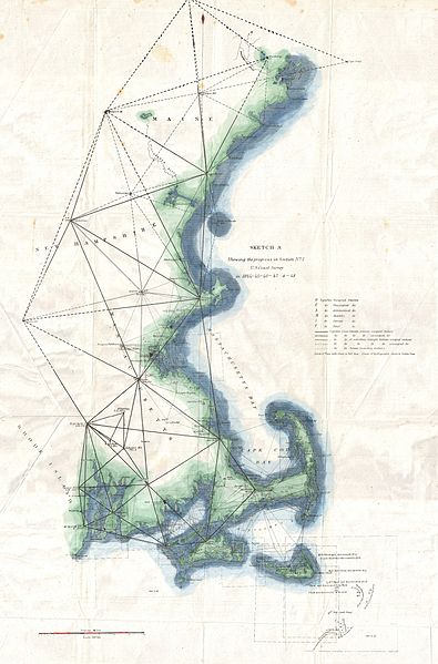
Sketch A Showing the
Progress in Section No. 1 U.S. Coast Survey in 1844 - 45 - 46 - 47 & - 48
160:
Sketch A Showing the
Progress in Section No. 1 U.S. Coast Survey in 1844 - 45 - 46 - 47 & - 48
117:
211:
906:"}},"text\/plain":{"en":{"P459":"SHA-1"}}}}": -->
245:
8:
1148:
228:
650:
faithful reproductions of two-dimensional public domain works of art are public domain
320:
work of art. The work of art itself is in the public domain for the following reason:
104:
696:
281:
277:
273:
269:
265:
261:
257:
253:
617:
608:
358:
317:
572:
518:
401:
599:
590:
581:
563:
554:
545:
536:
527:
509:
500:
491:
482:
473:
464:
455:
446:
437:
428:
419:
410:
392:
383:
374:
1076:
1031:
986:
923:
877:
837:
757:
311:
1105:
Click on a date/time to view the file as it appeared at that time.
316:
This is a faithful photographic reproduction of a two-dimensional,
657:
In other jurisdictions, re-use of this content may be restricted;
648:
The official position taken by the
Wikimedia Foundation is that "
363:
because it contains materials that originally came from the U.S.
241:
224:
369:, taken or made as part of an employee's official duties.
92:
690:
Add a one-line explanation of what this file represents
191:
82:(3,000 × 4,552 pixels, file size: 2.15 MB, MIME type:
1163:
1178:
1103:
116:
Commons is a freely licensed media file repository.
799:
work of the federal government of the United States
738:
work of the federal government of the United States
155:
366:National Oceanic and Atmospheric Administration
240:This file was provided to Wikimedia Commons by
205:
195:height: 23 in (58.4 cm); width: 15 in (38.1 cm)
97:
299:
183:
165:
218:
143:
14:
1056:
1011:
966:
1180:The following other wikis use this file:
929:866d3f98cad127ada40fb0baaa15f49c5cf432f8
348:
128:
343:
1096:
13:
695:
689:
635:
354:
239:
170:
129:
75:
1211:
694:
1164:
680:
347:
232:
96:
31:
21:
677:
171:
1175:
1100:
844:Geographicus Rare Antique Maps
818:Geographicus Rare Antique Maps
676:
242:Geographicus Rare Antique Maps
26:
1:
618:
609:
226:Washington, (1848 edition).
200:dimensions QS:P2049,15U218593
197:dimensions QS:P2048,23U218593
1160:
702:Items portrayed in this file
135:
7:
661:Reuse of PD-Art photographs
10:
1216:
1194:Usage on sr.wikipedia.org
1184:Usage on ar.wikipedia.org
149:United States Coast Survey
133:
131:
1198:Геодетска референта мрежа
1097:
573:
519:
402:
322:
134:
16:
1170:Geodetic control network
784:United States of America
730:United States of America
679:
600:
591:
582:
564:
555:
546:
537:
528:
510:
501:
492:
483:
474:
465:
456:
447:
438:
429:
420:
411:
393:
384:
375:
103:This is a file from the
36:
1154:
777:applies to jurisdiction
726:applies to jurisdiction
107:. Information from its
640:
110:description page there
41:Size of this preview:
1188:شبكة التحكم الجيوديسي
639:
355:This image is in the
1133:18:12, 24 March 2011
941:determination method
900:determination method
792:determination method
734:determination method
212:NewEngland-uscs-1848
210:Geographicus link:
69:3,000 × 4,552 pixels
65:1,350 × 2,048 pixels
246:cooperation project
219:Source/Photographer
47:Other resolutions:
641:
61:675 × 1,024 pixels
1176:Global file usage
1158:
1058:
1013:
968:
688:
673:
672:
669:
668:
645:
644:
630:
342:
341:
308:
305:Reusing this file
295:
294:
289:
125:
124:
105:Wikimedia Commons
32:Global file usage
1207:
1145:
1107:
1085:
1040:
995:
950:
945:
801:
796:
786:
781:
748:copyright status
718:copyright status
686:
638:
631:
626:
351:
350:
344:
338:
335:
332:
329:
324:
323:
312:
302:
290:
285:
236:
229:
206:Accession number
175:
139:
132:
121:
100:
99:
93:
87:
85:
72:
57:506 × 768 pixels
53:316 × 480 pixels
49:158 × 240 pixels
43:395 × 599 pixels
1215:
1214:
1210:
1209:
1208:
1206:
1205:
1204:
1174:
1166:
1159:
1151:
1143:
1099:
1098:
1095:
1094:
1093:
1092:
1091:
1090:
1089:
1088:
1086:
1083:
1073:
1072:
1071:
1069:
1050:
1049:
1048:
1047:
1046:
1045:
1044:
1043:
1041:
1038:
1028:
1027:
1026:
1024:
1005:
1004:
1003:
1002:
1001:
1000:
999:
998:
996:
993:
983:
982:
981:
979:
960:
959:
958:
957:
956:
955:
954:
953:
952:
951:
946:
943:
934:
933:
932:
930:
920:
919:
918:
916:
893:
892:
891:
890:
889:
888:
887:
886:
884:
874:
873:
872:
870:
855:
854:
853:
852:
851:
850:
849:
848:
846:
834:
833:
832:
830:
811:
810:
809:
808:
807:
806:
805:
804:
803:
802:
797:
794:
788:
787:
782:
779:
770:
769:
768:
766:
754:
753:
752:
750:
715:
714:
713:
712:
711:
709:
693:
692:
691:
674:
665:
646:
636:
620:
611:
602:
593:
584:
575:
566:
557:
548:
539:
530:
521:
512:
503:
494:
485:
476:
467:
458:
449:
440:
431:
422:
413:
404:
395:
386:
377:
373:
370:
336:
333:
330:
327:
321:
252:
249:
214:
201:
198:
179:
178:
161:
151:
138:
127:
126:
115:
114:
113:is shown below.
89:
83:
81:
74:
73:
46:
12:
11:
5:
1213:
1203:
1202:
1201:
1200:
1192:
1191:
1190:
1177:
1173:
1172:
1162:
1157:
1156:
1153:
1150:BotMultichillT
1149:
1146:
1142:3,000 × 4,552
1140:
1135:
1130:
1126:
1125:
1122:
1119:
1116:
1113:
1110:
1102:
1087:
1081:
1079:
1078:
1077:
1075:
1074:
1070:
1065:
1063:
1062:
1061:
1060:
1054:
1042:
1036:
1034:
1033:
1032:
1030:
1029:
1025:
1020:
1018:
1017:
1016:
1015:
1009:
997:
991:
989:
988:
987:
985:
984:
980:
975:
973:
972:
971:
970:
964:
939:
938:
937:
936:
935:
931:
928:
926:
925:
924:
922:
921:
917:
912:
910:
909:
908:
907:
905:
901:
897:
885:
882:
880:
879:
878:
876:
875:
871:
866:
864:
863:
862:
861:
859:
847:
842:
840:
839:
838:
836:
835:
831:
826:
824:
823:
822:
821:
819:
815:
790:
789:
775:
774:
773:
772:
771:
767:
762:
760:
759:
758:
756:
755:
751:
746:
744:
743:
742:
741:
739:
735:
731:
727:
723:
719:
710:
705:
703:
700:
699:
698:
697:
685:
684:
681:
678:
671:
670:
667:
666:
647:
643:
642:
633:
352:
340:
339:
315:
309:
297:
296:
293:
292:
237:
220:
216:
215:
209:
207:
203:
202:
199:
196:
193:
189:
188:
185:
181:
180:
169:
167:
163:
162:
159:
157:
153:
152:
147:
145:
141:
140:
136:
130:
123:
122:
101:
91:
90:
40:
35:
34:
29:
24:
19:
9:
6:
4:
3:
2:
1212:
1199:
1196:
1195:
1193:
1189:
1186:
1185:
1183:
1182:
1181:
1171:
1168:
1167:
1152:
1147:
1141:
1139:
1136:
1134:
1131:
1128:
1127:
1123:
1120:
1117:
1114:
1111:
1109:
1108:
1106:
1080:
1068:
1064:
1035:
1023:
1019:
990:
978:
974:
949:
942:
927:
915:
911:
881:
869:
865:
845:
841:
829:
825:
800:
793:
785:
778:
765:
764:public domain
761:
749:
745:
722:public domain
708:
704:
701:
682:
675:
664:
662:
656:
653:
651:
634:
632:
629:
625:
621:
616:
612:
607:
603:
598:
594:
589:
585:
580:
576:
571:
567:
562:
558:
553:
549:
544:
540:
535:
531:
526:
522:
517:
513:
508:
504:
499:
495:
490:
486:
481:
477:
472:
468:
463:
459:
454:
450:
445:
441:
436:
432:
427:
423:
418:
414:
409:
405:
400:
396:
391:
387:
382:
378:
371:
368:
367:
362:
361:
360:
359:public domain
353:
346:
345:
331:Public domain
328:Public domain
326:
325:
319:
318:public domain
314:
313:
310:
306:
301:
298:
291:
288:
283:
279:
275:
271:
267:
263:
259:
255:
250:
247:
243:
238:
235:
231:
230:
227:
225:
221:
217:
213:
208:
204:
194:
190:
186:
182:
174:
168:
164:
158:
154:
150:
146:
142:
119:
112:
111:
106:
102:
95:
94:
88:
79:
78:Original file
70:
66:
62:
58:
54:
50:
44:
39:
33:
30:
28:
25:
23:
20:
18:
15:
1179:
1104:
1101:File history
663:for details.
658:
654:
649:
623:
614:
605:
596:
587:
578:
569:
560:
551:
542:
533:
524:
520:Plattdüütsch
515:
506:
497:
488:
479:
470:
461:
452:
443:
434:
425:
416:
407:
398:
389:
380:
372:
364:
357:
356:
251:
223:
222:
187:1848 (dated)
172:
118:You can help
108:
76:
22:File history
583:slovenščina
166:Description
1161:File usage
1118:Dimensions
992:2,251,416
883:image/jpeg
868:media type
858:media type
828:collection
814:collection
601:Tiếng Việt
529:Nederlands
502:македонски
300:Permission
278:Nederlands
274:македонски
192:Dimensions
84:image/jpeg
27:File usage
1144:(2.15 MB)
1115:Thumbnail
1112:Date/Time
977:data size
963:data size
574:sicilianu
547:português
254:العربيَّة
173:English:
914:checksum
896:checksum
683:Captions
475:italiano
457:hrvatski
448:français
284: |
280: |
276: |
272: |
270:français
268: |
264: |
260: |
256: |
1129:current
1124:Comment
707:depicts
687:English
565:русский
421:español
412:English
394:Deutsch
385:čeština
376:العربية
262:English
258:Deutsch
80:
1082:3,000
1037:4,552
1022:height
1008:height
622:
613:
604:
595:
592:Türkçe
586:
577:
568:
559:
556:română
550:
541:
538:polski
532:
523:
514:
511:മലയാളം
505:
496:
487:
478:
469:
466:magyar
460:
451:
442:
433:
424:
415:
406:
403:Zazaki
397:
388:
379:
282:polski
144:Artist
1084:pixel
1067:width
1057:pixel
1053:width
1039:pixel
1012:pixel
948:SHA-1
904:SHA-1
439:suomi
430:eesti
337:false
334:false
266:suomi
156:Title
1121:User
994:byte
967:byte
659:see
619:繁體中文
610:简体中文
184:Date
17:File
628:+/−
493:한국어
484:日本語
287:+/−
944::
795::
780::
652:".
67:|
63:|
59:|
55:|
51:|
45:.
624:∙
615:∙
606:∙
597:∙
588:∙
579:∙
570:∙
561:∙
552:∙
543:∙
534:∙
525:∙
516:∙
507:∙
498:∙
489:∙
480:∙
471:∙
462:∙
453:∙
444:∙
435:∙
426:∙
417:∙
408:∙
399:∙
390:∙
381:∙
307:)
303:(
248:.
120:.
86:)
71:.
Text is available under the Creative Commons Attribution-ShareAlike License. Additional terms may apply.
