617:
674:
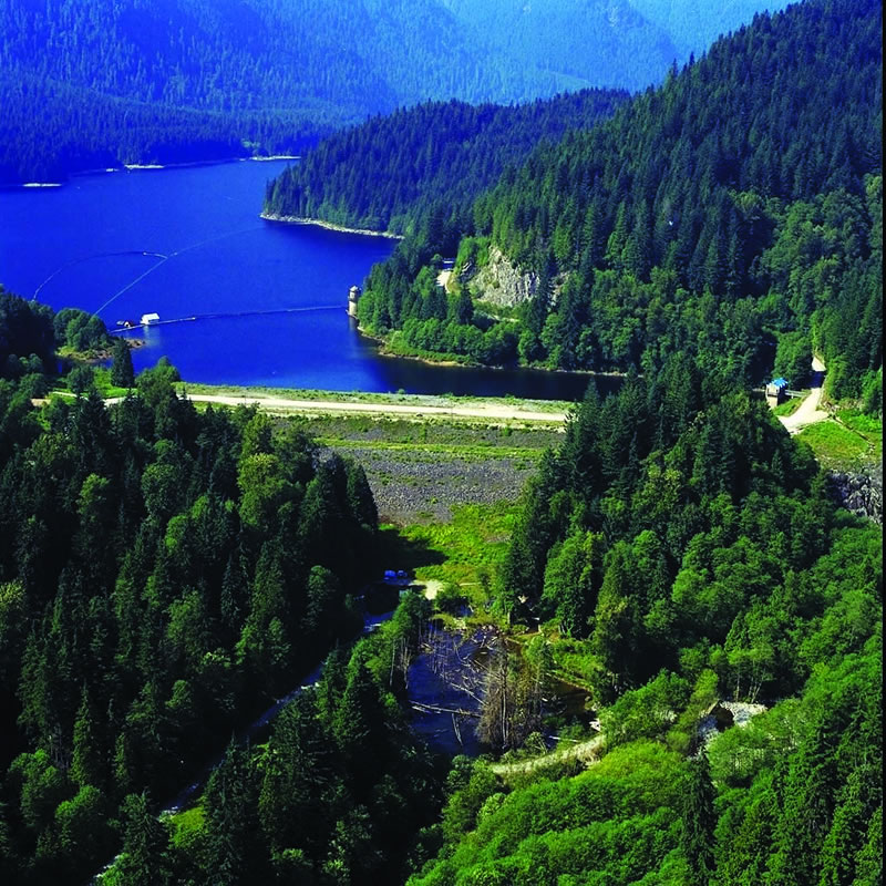
203:. By 1906 the original dam was discovered to be leaking, and while repairs were made the leak continued through 1908, until a second dam was completed in 1914. At the time of the tunnel's completion, it was the longest power diversion tunnel in the world. Due to seismic concerns, an embankment dam was built on the downstream side of the original rockfill dam in 2008.
178:
electrical generation infrastructure. It is also one of the main reservoirs for the
Greater Vancouver Water District. BC Hydro has released a new document in March 2018 that addresses emergency preparedness and outlines the areas effected should the dam fail as a result of an extreme earthquake
310:
557:
342:
467:
315:
247:
516:
290:
521:
472:
378:
531:
335:
511:
46:
735:
591:
444:
328:
270:
316:
https://www.bchydro.com/content/dam/BCHydro/customer-portal/documents/corporate/safety/March-2018-Coquitlam-Dam-Emergency-Prep-Map.pdf
755:
411:
230:
658:
596:
750:
439:
287:
191:
by five feet, was begun in April 1904, and completed in 1905. It was built to protect the water supply to powerhouses on
711:
740:
624:
397:
745:
730:
430:
402:
207:
651:
425:
388:
526:
547:
500:
562:
267:
704:
644:
406:
8:
536:
482:
351:
320:
227:
760:
685:
632:
487:
697:
492:
453:
449:
167:
34:
383:
294:
274:
234:
200:
159:
104:
681:
628:
586:
582:
457:
434:
188:
155:
135:
724:
552:
542:
477:
369:
61:
48:
461:
420:
196:
171:
616:
578:
506:
210:, no longer operating, was built to assist with the dam's construction.
496:
392:
373:
192:
163:
30:
175:
89:
170:. Although it has no powerhouse of its own, its waters divert to
355:
673:
187:
The first
Coquitlam Dam, built to raise the water level of
350:
722:
592:Great Recycling and Northern Development Canal
705:
652:
336:
680:This article about a dam or floodgate is a
228:Coquitlam River and Buntzen Lake Watersheds
712:
698:
659:
645:
343:
329:
597:North American Water and Power Alliance
723:
262:
260:
736:Buildings and structures in Coquitlam
324:
668:
611:
539:(Julian, Kanairiktok & Naskaupi)
257:
248:"Coquitlam Dam Emergency Flood Map"
13:
16:Dam in Coquitlam, British Columbia
14:
772:
304:
672:
615:
756:Metro Vancouver geography stubs
280:
240:
220:
1:
751:Publicly owned dams in Canada
311:Aerial image of dam, BC Hydro
288:Coquitlam Dam Seismic Upgrade
277:Retrieved on 22 February 2009
237:Retrieved on 22 February 2009
213:
199:, and also supplied water to
684:. You can help Knowledge by
631:. You can help Knowledge by
208:Port Moody-Coquitlam Railway
7:
352:Interbasin water diversions
268:Coquitlam Watershed History
10:
777:
667:
610:
182:
571:
412:Columbia-Kootenay (canal)
362:
141:
131:
126:
118:
110:
100:
95:
85:
77:
40:
26:
21:
741:Dams in British Columbia
527:Saint John Water Supply
297:Retrieved 12 March 2009
746:Dams completed in 1914
731:Geography of Coquitlam
627:location article is a
62:49.35389°N 122.77694°W
435:Squamish (Cheakamus)
407:Southern Indian Lake
174:, making it part of
154:is a hydraulic fill
67:49.35389; -122.77694
537:Smallwood Reservoir
58: /
293:2009-02-15 at the
273:2006-10-07 at the
233:2007-10-13 at the
195:, via a tunnel to
693:
692:
640:
639:
605:
604:
548:Vernon Irrigation
532:Sault aux Cochons
493:Nechako Diversion
473:Lac de la Frégate
450:James Bay Project
149:
148:
142:Surface area
96:Dam and spillways
78:Opening date
768:
714:
707:
700:
676:
669:
661:
654:
647:
619:
612:
363:Water diversions
345:
338:
331:
322:
321:
298:
284:
278:
264:
255:
254:
252:
244:
238:
224:
168:British Columbia
73:
72:
70:
69:
68:
63:
59:
56:
55:
54:
51:
35:British Columbia
19:
18:
776:
775:
771:
770:
769:
767:
766:
765:
721:
720:
719:
718:
666:
665:
625:Metro Vancouver
608:
606:
601:
567:
558:Wellington Lake
512:Opasatika River
488:Mégiscane River
358:
349:
307:
302:
301:
295:Wayback Machine
285:
281:
275:Wayback Machine
265:
258:
250:
246:
245:
241:
235:Wayback Machine
225:
221:
216:
201:New Westminster
185:
162:in the city of
160:Coquitlam River
105:Coquitlam River
66:
64:
60:
57:
52:
49:
47:
45:
44:
17:
12:
11:
5:
774:
764:
763:
758:
753:
748:
743:
738:
733:
717:
716:
709:
702:
694:
691:
690:
677:
664:
663:
656:
649:
641:
638:
637:
620:
603:
602:
600:
599:
594:
589:
575:
573:
569:
568:
566:
565:
560:
555:
550:
545:
540:
534:
529:
524:
519:
514:
509:
504:
490:
485:
480:
475:
470:
465:
447:
442:
437:
428:
423:
414:
409:
400:
398:Campbell–Heber
395:
386:
381:
376:
366:
364:
360:
359:
348:
347:
340:
333:
325:
319:
318:
313:
306:
305:External links
303:
300:
299:
279:
256:
239:
218:
217:
215:
212:
189:Coquitlam Lake
184:
181:
156:embankment dam
147:
146:
143:
139:
138:
136:Coquitlam Lake
133:
129:
128:
124:
123:
120:
116:
115:
112:
108:
107:
102:
98:
97:
93:
92:
87:
83:
82:
79:
75:
74:
42:
38:
37:
28:
24:
23:
15:
9:
6:
4:
3:
2:
773:
762:
759:
757:
754:
752:
749:
747:
744:
742:
739:
737:
734:
732:
729:
728:
726:
715:
710:
708:
703:
701:
696:
695:
689:
687:
683:
678:
675:
671:
670:
662:
657:
655:
650:
648:
643:
642:
636:
634:
630:
626:
621:
618:
614:
613:
609:
598:
595:
593:
590:
588:
584:
580:
577:
576:
574:
570:
564:
561:
559:
556:
554:
551:
549:
546:
544:
543:Swift Current
541:
538:
535:
533:
530:
528:
525:
523:
520:
518:
515:
513:
510:
508:
505:
502:
498:
494:
491:
489:
486:
484:
481:
479:
478:Lake Manouane
476:
474:
471:
469:
466:
463:
459:
455:
451:
448:
446:
443:
441:
438:
436:
432:
429:
427:
424:
422:
418:
415:
413:
410:
408:
404:
401:
399:
396:
394:
390:
387:
385:
382:
380:
377:
375:
371:
368:
367:
365:
361:
357:
353:
346:
341:
339:
334:
332:
327:
326:
323:
317:
314:
312:
309:
308:
296:
292:
289:
283:
276:
272:
269:
263:
261:
249:
243:
236:
232:
229:
223:
219:
211:
209:
204:
202:
198:
194:
190:
180:
177:
173:
169:
165:
161:
157:
153:
152:Coquitlam Dam
144:
140:
137:
134:
130:
125:
121:
117:
113:
109:
106:
103:
99:
94:
91:
88:
84:
80:
76:
71:
43:
39:
36:
32:
29:
25:
22:Coquitlam Dam
20:
686:expanding it
679:
633:expanding it
622:
607:
468:Jordan River
445:Ingram River
426:Cypress Lake
416:
389:Bridge River
384:Bay d'Espoir
282:
242:
222:
205:
197:Buntzen Lake
186:
172:Buntzen Lake
151:
150:
579:Chilko Lake
507:Ogoki River
454:Caniapiscau
266:Will Koop:
86:Operator(s)
65: /
53:122°46′37″W
41:Coordinates
725:Categories
563:Wreck Cove
522:Root River
497:Kenney Dam
431:Daisy Lake
393:Seton Lake
286:BC Hydro:
226:BC Hydro:
214:References
193:Indian Arm
176:BC Hydro's
50:49°21′14″N
761:Dam stubs
583:Tatlayoko
483:Long Lake
440:Deer Lake
417:Coquitlam
403:Churchill
164:Coquitlam
127:Reservoir
31:Coquitlam
587:Homathko
572:Proposed
553:Wahleach
460:, &
458:Eastmain
379:Barrière
370:Alouette
291:Archived
271:Archived
231:Archived
101:Impounds
90:BC Hydro
27:Location
517:Pasquia
421:Buntzen
183:History
179:event.
158:on the
145:1100 ha
132:Creates
501:Kemano
462:Rupert
356:Canada
119:Length
111:Height
623:This
374:Stave
251:(PDF)
122:290 m
682:stub
629:stub
206:The
114:31 m
81:1914
354:in
727::
456:,
259:^
166:,
33:,
713:e
706:t
699:v
688:.
660:e
653:t
646:v
635:.
585:/
581:-
503:)
499:-
495:(
464:)
452:(
433:-
419:–
405:–
391:-
372:-
344:e
337:t
330:v
253:.
Text is available under the Creative Commons Attribution-ShareAlike License. Additional terms may apply.