165:); hence clouds exchange thermal radiation between their bases and the underlying planetary surface (land or ocean) by absorbing and re-emitting this infrared radiation at the prevailing temperature – the lower the cloud base, the warmer the cloud particles and the higher the rate of emission. For a synthetic discussion of the impact of clouds (and in particular the role of cloud bases) on climate systems, see the
33:
126:
Divide the spread by 4.4 (if temperatures are in °F) or 2.5 (if temperatures are in °C), then multiply by 1000. This will give the altitude of the cloud base in feet above ground level. Put in a simpler way, 400 feet for every 1°C dew point spread. For metric divide the spread in °C by 8 and multiply
146:, many (or even most) clouds may have a similar cloud base because this variable is largely controlled by the thermodynamic properties of that air mass, which are relatively homogeneous on a large spatial scale. This is not the case for the
260:
The prefix "nimbo-" or the suffix "-nimbus" are low-level clouds that have their bases below 2,000 meters (6,500 feet) above the Earth. Clouds that produce rain and snow fall into this category.
311:
302:
297:
284:
162:
19:
This article is about the concept in meteorology. For the fictional skyborne headquarters in the
British television series
341:
307:
21:
130:
Add the results from step (2) to the field elevation to obtain the altitude of the cloud base above mean sea level.
112:
172:
Cloud base is an important meteorological variable for aviation safety, as it determines whether pilots may use
228:
161:
in the atmosphere. In the thermal spectral domain, water is a strong absorber (and thus emitter, according to
150:, which can vary widely from cloud to cloud, as the depth of the cloud is determined by the strength of local
336:
88:. This device reflects a beam of light off the cloud base and then calculates its distance using either
108:
139:
Rain clouds and snow clouds are clouds that have their bases below 2,000 meters above the ground.
177:
151:
244:
65:
61:
8:
173:
224:
166:
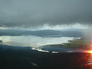
331:
315:
189:
99:
Alternatively, the cloud base can be estimated from surface measurements of air
325:
89:
69:
199:
194:
100:
85:
73:
158:
147:
120:
41:
26:
143:
104:
53:
37:
281:, Her Majesty's Stationery Office, Met. O. 842, A.P. 897, 319 p.
274:, American Meteorological Society, Boston, Second printing-1970.
285:
FAA Pilot's
Handbook of Aeronautical Knowledge, Weather Theory
93:
57:
32:
119:
Find the difference between the surface temperature and the
310:– a lesson plan from the National Science Digital Library (
60:. It is traditionally expressed either in metres or feet
84:
The height of the cloud base can be measured using a
115:and often named after Tom Bradbury, is as follows:
237:
323:
134:
36:Photo of a cloud base taken above the island of
111:. One method for doing this, used by the U.S.
298:National Science Digital Library - Cloud Base
127:by 1000 and get the cloud base in meters.
52:(or the base of the cloud) is the lowest
68:level corresponding to this altitude in
64:or above a planetary surface, or as the
31:
324:
157:Clouds greatly affect the transfer of
123:. This value is known as the "spread".
218:
163:Kirchhoff's law of thermal radiation
13:
14:
353:
291:
22:Captain Scarlet and the Mysterons
303:Cloud base Measuring instruments
223:. A&C Black Publishers Ltd.
113:Federal Aviation Administration
16:Height of the bottom of a cloud
212:
79:
1:
205:
169:, in particular chapter 7.2.
135:Weather and climate relevance
167:IPCC Third Assessment Report
56:of the visible portion of a
7:
183:
10:
358:
180:for take-off and landing.
18:
342:Meteorological quantities
270:Huschke, Ralph E. (1959)
109:lifted condensation level
72:(hPa, equivalent to the
314:12 October 2007 at the
308:Measuring Cloud Heights
279:Meteorological Glossary
277:McIntosh, D. H. (1972)
272:Glossary of Meteorology
178:instrument flight rules
221:Meteorology and Flight
45:
35:
62:above mean sea level
174:visual flight rules
107:by calculating the
337:Gliding technology
249:National Geography
46:
349:
263:
262:
257:
256:
241:
235:
234:
216:
142:In well-defined
357:
356:
352:
351:
350:
348:
347:
346:
322:
321:
316:Wayback Machine
294:
267:
266:
254:
252:
243:
242:
238:
231:
219:Bradbury, Tom.
217:
213:
208:
190:Ceiling (cloud)
186:
137:
82:
30:
17:
12:
11:
5:
355:
345:
344:
339:
334:
320:
319:
305:
300:
293:
292:External links
290:
289:
288:
282:
275:
265:
264:
236:
229:
210:
209:
207:
204:
203:
202:
197:
192:
185:
182:
136:
133:
132:
131:
128:
124:
81:
78:
15:
9:
6:
4:
3:
2:
354:
343:
340:
338:
335:
333:
330:
329:
327:
317:
313:
309:
306:
304:
301:
299:
296:
295:
286:
283:
280:
276:
273:
269:
268:
261:
250:
246:
240:
232:
226:
222:
215:
211:
201:
198:
196:
193:
191:
188:
187:
181:
179:
175:
170:
168:
164:
160:
155:
153:
149:
145:
140:
129:
125:
122:
118:
117:
116:
114:
110:
106:
102:
97:
95:
91:
90:triangulation
87:
77:
75:
71:
67:
63:
59:
55:
51:
43:
39:
34:
28:
24:
23:
278:
271:
259:
253:. Retrieved
251:. 2022-08-09
248:
239:
220:
214:
200:Cloud height
171:
156:
141:
138:
98:
83:
70:hectopascals
49:
47:
20:
195:Cloud cover
101:temperature
94:travel time
80:Measurement
326:Categories
255:2023-09-06
230:0713668318
206:References
152:convection
148:cloud tops
144:air masses
86:ceilometer
50:cloud base
176:(VFR) or
159:radiation
121:dew point
44:, in 2005
42:Indonesia
27:Cloudbase
312:Archived
184:See also
105:humidity
74:millibar
66:pressure
54:altitude
38:Sulawesi
245:"Cloud"
332:Clouds
227:
25:, see
287:p. 14
58:cloud
225:ISBN
103:and
92:or
76:).
328::
258:.
247:.
154:.
96:.
48:A
40:,
318:)
233:.
29:.
Text is available under the Creative Commons Attribution-ShareAlike License. Additional terms may apply.
