47:
262:
253:
31:
244:
54:
207:. The Bluffton Area—300 acres (120 ha) on the north shore—is the most developed and receives extensive use. The Page Creek Area—500 acres (200 ha) on the south shore—offers primitive camping as well as 36 utility sites. West of the Page Creek Area are the
90:
552:
474:
436:
766:
739:
280:
46:
408:
519:
322:
457:
429:
466:
509:
445:
377:
565:
313:
481:
422:
337:
486:
524:
491:
701:
514:
318:
761:
621:
218:
from which the reservoir's name was derived (junipers were often misidentified as "cedars" by early settlers).
308:
611:
542:
203:
is divided into two areas, comprising 850 acres (340 ha), straddling the 6,800-acre (2,800 ha)
721:
588:
560:
275:
681:
616:
501:
285:
221:
Threshing
Machine Canyon, the site of an 1850s Native American attack on a wagon train bearing a
696:
706:
661:
636:
204:
656:
651:
646:
626:
185:
402:
355:
165:
8:
666:
631:
716:
676:
606:
534:
711:
691:
601:
222:
686:
671:
177:
755:
193:
181:
105:
92:
78:
414:
641:
261:
200:
176:
is a public recreation area located 21 miles (34 km) southeast of
252:
30:
212:
243:
208:
579:
449:
226:
189:
74:
229:
one can find carvings dating back to the mid-19th century.
215:
225:, is accessed by a road west of the park. In the historic
378:"Cedar Bluff Reservoir, State Park, and Wildlife Area"
358:. Kansas Department of Wildlife, Parks and Tourism
753:
740:Kansas Department of Wildlife, Parks and Tourism
411:Kansas Department of Wildlife, Parks and Tourism
405:Kansas Department of Wildlife, Parks and Tourism
338:"Top 5 most popular Kansas state parks revealed"
157:Kansas Department of Wildlife, Parks and Tourism
53:
444:
430:
281:List of lakes, reservoirs, and dams in Kansas
467:National Historic Sites and Historical Park
587:
437:
423:
370:
323:United States Department of the Interior
767:Protected areas of Trego County, Kansas
380:. Kansas Office of Tourism & Travel
180:and 23 miles (37 km) southwest of
754:
303:
301:
418:
348:
335:
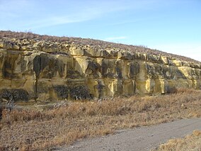
35:Limestone on the edge of Cedar Bluff
566:Tallgrass Prairie National Preserve
314:Geographic Names Information System
298:
16:State park in Kansas, United States
13:
211:-lined, 100-foot-tall (30 m)
14:
778:
396:
336:Self, Matthew (August 18, 2023).
260:
251:
242:
52:
45:
29:
319:United States Geological Survey
309:"Cedar Bluff State Park Office"
329:
238:Views of Cedar Bluff Reservoir
1:
291:
7:
476:Brown v. Board of Education
269:
10:
783:
561:Big Basin Prairie Preserve
276:List of Kansas state parks
232:
149:182,252 (in 2022)
133:2,185 ft (666 m)
734:
578:
551:
533:
502:National Wildlife Refuges
500:
465:
456:
409:Cedar Bluff Reservoir Map
161:
153:
145:
137:
129:
121:
84:
69:
40:
28:
23:
356:"Cedar Bluff State Park"
286:List of rivers of Kansas
125:850 acres (340 ha)
403:Cedar Bluff State Park
174:Cedar Bluff State Park
166:Cedar Bluff State Park
73:Trego County, Kansas,
24:Cedar Bluff State Park
762:State parks of Kansas
553:Other Protected Areas
205:Cedar Bluff Reservoir
106:38.81139°N 99.73250°W
702:Prairie Spirit Trail
535:National Grasslands
154:Governing body
111:38.81139; -99.73250
102: /
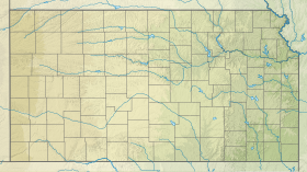
61:Location in Kansas
749:
748:
730:
729:
574:
573:
520:Marais des Cygnes
223:threshing machine
171:
170:
774:
585:
584:
463:
462:
439:
432:
425:
416:
415:
390:
389:
387:
385:
374:
368:
367:
365:
363:
352:
346:
345:
333:
327:
326:
305:
264:
255:
246:
117:
116:
114:
113:
112:
107:
103:
100:
99:
98:
95:
56:
55:
49:
33:
21:
20:
782:
781:
777:
776:
775:
773:
772:
771:
752:
751:
750:
745:
726:
570:
547:
529:
496:
452:
446:Protected areas
443:
399:
394:
393:
383:
381:
376:
375:
371:
361:
359:
354:
353:
349:
334:
330:
307:
306:
299:
294:
272:
265:
256:
247:
235:
110:
108:
104:
101:
96:
93:
91:
89:
88:
65:
64:
63:
62:
59:
58:
57:
36:
17:
12:
11:
5:
780:
770:
769:
764:
747:
746:
744:
743:
735:
732:
731:
728:
727:
725:
724:
719:
714:
709:
704:
699:
694:
689:
684:
679:
674:
669:
664:
659:
654:
649:
644:
639:
634:
629:
624:
619:
614:
609:
604:
599:
593:
591:
582:
576:
575:
572:
571:
569:
568:
563:
557:
555:
549:
548:
546:
545:
539:
537:
531:
530:
528:
527:
522:
517:
512:
506:
504:
498:
497:
495:
494:
489:
484:
479:
471:
469:
460:
454:
453:
442:
441:
434:
427:
419:
413:
412:
406:
398:
397:External links
395:
392:
391:
369:
347:
328:
296:
295:
293:
290:
289:
288:
283:
278:
271:
268:
267:
266:
259:
257:
250:
248:
241:
239:
234:
231:
169:
168:
163:
159:
158:
155:
151:
150:
147:
143:
142:
139:
135:
134:
131:
127:
126:
123:
119:
118:
86:
82:
81:
71:
67:
66:
60:
51:
50:
44:
43:
42:
41:
38:
37:
34:
26:
25:
15:
9:
6:
4:
3:
2:
779:
768:
765:
763:
760:
759:
757:
742:
741:
737:
736:
733:
723:
720:
718:
715:
713:
710:
708:
705:
703:
700:
698:
695:
693:
690:
688:
685:
683:
682:Mushroom Rock
680:
678:
675:
673:
670:
668:
665:
663:
660:
658:
655:
653:
650:
648:
645:
643:
640:
638:
635:
633:
630:
628:
625:
623:
620:
618:
617:Cross Timbers
615:
613:
610:
608:
605:
603:
600:
598:
595:
594:
592:
590:
586:
583:
581:
577:
567:
564:
562:
559:
558:
556:
554:
550:
544:
541:
540:
538:
536:
532:
526:
523:
521:
518:
516:
513:
511:
508:
507:
505:
503:
499:
493:
490:
488:
485:
483:
480:
478:
477:
473:
472:
470:
468:
464:
461:
459:
455:
451:
447:
440:
435:
433:
428:
426:
421:
420:
417:
410:
407:
404:
401:
400:
379:
373:
357:
351:
343:
339:
332:
324:
320:
316:
315:
310:
304:
302:
297:
287:
284:
282:
279:
277:
274:
273:
263:
258:
254:
249:
245:
240:
237:
236:
230:
228:
224:
219:
217:
214:
210:
206:
202:
197:
195:
194:United States
191:
187:
183:
179:
175:
167:
164:
160:
156:
152:
148:
144:
140:
136:
132:
128:
124:
120:
115:
87:
83:
80:
79:United States
76:
72:
68:
48:
39:
32:
27:
22:
19:
738:
712:Tuttle Creek
596:
475:
382:. Retrieved
372:
362:November 22,
360:. Retrieved
350:
341:
331:
312:
220:
198:
186:Trego County
173:
172:
18:
697:Prairie Dog
597:Cedar Bluff
589:State Parks
510:Flint Hills
482:Fort Larned
138:Established
109: /
85:Coordinates
756:Categories
707:Sand Hills
662:Lake Scott
642:Glen Elder
637:Fall River
622:Eisenhower
487:Fort Scott
292:References
201:state park
97:99°43′57″W
94:38°48′41″N
657:Kanopolis
652:Kaw River
647:Hillsdale
627:El Dorado
492:Nicodemus
213:limestone
130:Elevation
667:Lovewell
632:Elk City
612:Crawford
543:Cimarron
270:See also
178:WaKeeney
146:Visitors
70:Location
717:Webster
677:Milford
607:Clinton
525:Quivira
458:Federal
384:May 24,
233:Gallery
209:juniper
162:Website
722:Wilson
692:Pomona
602:Cheney
515:Kirwin
450:Kansas
227:canyon
216:bluffs
190:Kansas
75:Kansas
687:Perry
672:Meade
580:State
182:Ellis
386:2017
364:2012
342:KSNT
199:The
141:1962
122:Area
448:of
184:in
758::
340:.
321:,
317:.
311:.
300:^
196:.
192:,
188:,
77:,
438:e
431:t
424:v
388:.
366:.
344:.
325:.
Text is available under the Creative Commons Attribution-ShareAlike License. Additional terms may apply.


