147:
391:
314:
131:
25:
154:
299:
It is separated into two sections: Inner Bonne Bay and Outer Bonne Bay. Inner Bonne Bay consists of two arms, one which is south which has wooded coves and beach landings. Outer Bonne Bay consists of the entrance to the fjord of Bonne Bay. Bonne Bay was carved out approximately 10,000 years ago by
193:
432:
310:
is found on the eastern side. Soils on mafic rock belong to the
Serpentine Cove Association, while sedimentary rock supports the Cox's Cove Association.
461:
300:
two large glaciers in each one of the arms. The glaciers then came together in the middle part of the Bay and continued to push on out to the ocean.
330:, Bonne Bay Marine station, kayak tours, Deer Lake insectarium, fishing and trouting, hiking, biking, boat tours, water taxis, and museums.
456:
425:
451:
146:
352:
418:
89:
61:
108:
68:
46:
376:
75:
42:
57:
398:
285:
250:
357:
327:
293:
289:
175:
347:
35:
234:
179:
8:
82:
390:
406:
307:
264:
402:
288:, Canada. It is located on the western coast of Newfoundland and separates the
244:
445:
317:
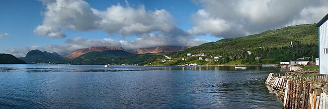
Bonne Bay in Woody Point, with the Gros Morne
National Park in the background
209:
195:
135:
Norris Point, at the junction of the South Arm and the East Arm of Bonne Bay
313:
130:
24:
377:
Soils of the Sandy Lake-Bay of
Islands Area, Western Newfoundland
303:
306:
rock underlies the western shores of Bonne Bay, and clastic
273:
276:
270:
267:
49:. Unsourced material may be challenged and removed.
443:
186:
426:
292:from the rest of the island. It is a part of
433:
419:
462:Newfoundland and Labrador geography stubs
109:Learn how and when to remove this message
312:
444:
326:Recreation in Bonne Bay consists of:
385:
47:adding citations to reliable sources
18:
457:Fjords of Newfoundland and Labrador
13:
14:
473:
452:Bays of Newfoundland and Labrador
153:
389:
263:
152:
145:
129:
23:
34:needs additional citations for
370:
340:
1:
333:
321:
405:. You can help Knowledge by
353:Geographical Names Data Base
7:
16:Bay in Newfoundland, Canada
10:
478:
384:
399:Newfoundland and Labrador
251:Newfoundland and Labrador
243:
233:
185:
171:
140:
128:
123:
358:Natural Resources Canada
328:Gros Morne National Park
294:Gros Morne National Park
290:Great Northern Peninsula
176:Gros Morne National Park
401:location article is a
318:
316:
210:49.55333°N 57.93139°W
43:improve this article
215:49.55333; -57.93139
205: /
319:
414:
413:
257:
256:
178:on the island of
119:
118:
111:
93:
469:
435:
428:
421:
393:
386:
379:
374:
368:
367:
365:
364:
344:
308:sedimentary rock
283:
282:
279:
278:
275:
272:
269:
229:
228:
226:
225:
224:
222:
217:
216:
211:
206:
203:
202:
201:
198:
188:
156:
155:
149:
133:
121:
120:
114:
107:
103:
100:
94:
92:
51:
27:
19:
477:
476:
472:
471:
470:
468:
467:
466:
442:
441:
440:
439:
383:
382:
375:
371:
362:
360:
346:
345:
341:
336:
324:
266:
262:
247: countries
220:
218:
214:
212:
208:
207:
204:
199:
196:
194:
192:
191:
167:
166:
165:
164:
163:
162:
161:
157:
136:
115:
104:
98:
95:
52:
50:
40:
28:
17:
12:
11:
5:
475:
465:
464:
459:
454:
438:
437:
430:
423:
415:
412:
411:
394:
381:
380:
369:
338:
337:
335:
332:
323:
320:
255:
254:
248:
241:
240:
237:
231:
230:
189:
183:
182:
173:
169:
168:
159:
158:
151:
150:
144:
143:
142:
141:
138:
137:
134:
126:
125:
117:
116:
31:
29:
22:
15:
9:
6:
4:
3:
2:
474:
463:
460:
458:
455:
453:
450:
449:
447:
436:
431:
429:
424:
422:
417:
416:
410:
408:
404:
400:
395:
392:
388:
387:
378:
373:
359:
355:
354:
349:
343:
339:
331:
329:
315:
311:
309:
305:
301:
297:
295:
291:
287:
281:
261:
252:
249:
246:
242:
238:
236:
232:
227:
190:
184:
181:
177:
174:
170:
148:
139:
132:
127:
122:
113:
110:
102:
99:December 2009
91:
88:
84:
81:
77:
74:
70:
67:
63:
60: –
59:
55:
54:Find sources:
48:
44:
38:
37:
32:This article
30:
26:
21:
20:
407:expanding it
396:
372:
361:. Retrieved
351:
342:
325:
302:
298:
286:Newfoundland
284:is a bay in
259:
258:
180:Newfoundland
105:
96:
86:
79:
72:
65:
53:
41:Please help
36:verification
33:
348:"Bonne Bay"
213: /
187:Coordinates
58:"Bonne Bay"
446:Categories
363:2020-06-21
334:References
322:Recreation
219: (
200:57°55′53″W
197:49°33′12″N
69:newspapers
260:Bonne Bay
221:Bonne Bay
160:Bonne Bay
124:Bonne Bay
253:, Canada
172:Location
83:scholar
85:
78:
71:
64:
56:
397:This
304:Mafic
245:Basin
239:Fiord
90:JSTOR
76:books
403:stub
235:Type
62:news
45:by
448::
356:.
350:.
296:.
434:e
427:t
420:v
409:.
366:.
280:/
277:n
274:ɒ
271:b
268:ˈ
265:/
223:)
112:)
106:(
101:)
97:(
87:·
80:·
73:·
66:·
39:.
Text is available under the Creative Commons Attribution-ShareAlike License. Additional terms may apply.


