173:
26:
238:
All locks of the
Tennessee-Tombigbee Waterway operate 24 hours a day, 7 days a week. For large vessels, lock operation is made on demand. For pleasure boats using the Amory Lock, the lock operates in the morning at 5, 7, 9, and 11 A.M., and in the afternoon at 1, 3, 5, and 7 P.M.
247:
Certain vessels are given priority over others wishing to use the Amory Lock. The priority status from greatest to least is: U.S. military craft, commercial passenger craft, commercial tows, commercial fisherman, pleasure boats.
294:
439:
331:
42:
204:, and the waterway forms the west and north boundary of the city. Mississippi Highway 6 crosses the waterway at an overpass south of the Amory Lock.
316:
207:
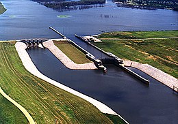
The Amory Lock is located at mile 371.1 on the waterway, representing the navigational distance from the southern end of the waterway at the
298:
272:
444:
429:
227:
The Amory Lock was constructed at a cost of $ 23.3 million, and it created a 914 acres (370 ha) lake north of the lock and dam.
338:
124:
230:
All locks on the waterway use marine radio channel 16 for standby; the Amory Lock's unique marine radio channel is 14.
208:
346:
348:
86:
434:
373:
352:
189:
408:
363:
114:
368:
324:
403:
378:
8:
388:
201:
398:
216:
423:
212:
58:
44:
393:
104:
172:
25:
440:
Buildings and structures in Monroe County, Mississippi
421:
297:. Tennessee-Tombigbee Waterway. Archived from
332:
339:
325:
24:
200:The Amory Lock is located in the city of
171:
267:
265:
263:
261:
422:
320:
125:United States Army Corps of Engineers
258:
242:
13:
445:1984 establishments in Mississippi
14:
456:
222:
287:
275:. U.S. Army Corps of Engineers
273:"Tennessee-Tombigbee Waterway"
209:Cochrane–Africatown USA Bridge
1:
251:
430:Tennessee–Tombigbee Waterway
353:U.S. Army Corps of Engineers
349:Tennessee-Tombigbee Waterway
190:Tennessee-Tombigbee Waterway
87:Tennessee–Tombigbee Waterway
7:
295:"Tennessee-Tombigbee Locks"
233:
195:
188:) is a lock and dam on the
10:
461:
359:
162:
154:
146:
138:
130:
120:
110:
100:
92:
82:
39:
35:
23:
18:
150:600 ft (180 m)
166:30 ft (9.1 m)
158:110 ft (34 m)
347:Locks and Dams on the
177:
175:
59:34.01111°N 88.48917°W
435:Dams in Mississippi
64:34.01111; -88.48917
54: /
351:Maintained by the
301:on August 17, 2011
202:Amory, Mississippi
178:
121:Maintained by
70:Amory Lock and Dam
30:Amory Lock and Dam
417:
416:
243:Priority of usage
170:
169:
452:
341:
334:
327:
318:
317:
311:
310:
308:
306:
291:
285:
284:
282:
280:
269:
184:(formerly named
139:First built
78:
77:
75:
74:
73:
71:
66:
65:
60:
55:
52:
51:
50:
47:
28:
16:
15:
460:
459:
455:
454:
453:
451:
450:
449:
420:
419:
418:
413:
404:G.V. Montgomery
374:John C. Stennis
355:
345:
315:
314:
304:
302:
293:
292:
288:
278:
276:
271:
270:
259:
254:
245:
236:
225:
217:Mobile, Alabama
198:
69:
67:
63:
61:
57:
56:
53:
48:
45:
43:
41:
40:
31:
12:
11:
5:
458:
448:
447:
442:
437:
432:
415:
414:
412:
411:
406:
401:
396:
391:
389:Glover Wilkins
386:
381:
376:
371:
366:
360:
357:
356:
344:
343:
336:
329:
321:
313:
312:
286:
256:
255:
253:
250:
244:
241:
235:
232:
224:
223:Specifications
221:
197:
194:
168:
167:
164:
160:
159:
156:
152:
151:
148:
144:
143:
140:
136:
135:
132:
128:
127:
122:
118:
117:
112:
108:
107:
102:
98:
97:
94:
90:
89:
84:
80:
79:
37:
36:
33:
32:
29:
21:
20:
9:
6:
4:
3:
2:
457:
446:
443:
441:
438:
436:
433:
431:
428:
427:
425:
410:
409:Jamie Whitten
407:
405:
402:
400:
397:
395:
392:
390:
387:
385:
382:
380:
377:
375:
372:
370:
367:
365:
364:Howell Heflin
362:
361:
358:
354:
350:
342:
337:
335:
330:
328:
323:
322:
319:
300:
296:
290:
274:
268:
266:
264:
262:
257:
249:
240:
231:
228:
220:
218:
214:
213:U.S. Route 90
210:
205:
203:
193:
191:
187:
183:
174:
165:
161:
157:
153:
149:
145:
141:
137:
133:
129:
126:
123:
119:
116:
115:Monroe County
113:
109:
106:
103:
99:
96:United States
95:
91:
88:
85:
81:
76:
38:
34:
27:
22:
17:
383:
303:. Retrieved
299:the original
289:
277:. Retrieved
246:
237:
229:
226:
206:
199:
185:
181:
179:
399:John Rankin
105:Mississippi
62: /
424:Categories
369:Tom Bevill
252:References
182:Amory Lock
176:Amory Lock
68: (
49:88°29′21″W
46:34°00′40″N
19:Amory Lock
134:Hydraulic
131:Operation
379:Aberdeen
234:Schedule
196:Location
83:Waterway
305:May 21,
279:May 21,
93:Country
394:Fulton
186:Lock A
147:Length
111:County
384:Amory
155:Width
101:State
307:2017
281:2017
180:The
163:Fall
142:1984
215:in
211:on
426::
260:^
219:.
192:.
340:e
333:t
326:v
309:.
283:.
72:)
Text is available under the Creative Commons Attribution-ShareAlike License. Additional terms may apply.

