50:
27:
83:
484:
36:
90:
57:
318:
383:
The eastern part of the island is often called the "backside" of the island since it is on the other side of the mountains from the more populous side. This "backside" lies inside the municipality of
Leirfjord and the
306:
mountain range which has five mountains that are more than 1,000 metres (3,300 ft) tall, while the western part of the island is relatively flat and it is the location of the town of
350:
372:
on the mainland. This same highway 17 continues across the island from north to south where it then connects by bridge to the nearby islands of
299:
525:
325:
The 30-kilometre (19 mi) long island has an area of 152.6 square kilometres (58.9 sq mi), and its highest point is the mountain
326:
311:
329:, which reaches 1,072 metres (3,517 ft) above sea level. In 2017, there were 6,969 residents on the island. The islands of
139:
49:
518:
559:
511:
554:
82:
401:
365:
453:
8:
549:
544:
377:
338:
458:
26:
361:
385:
303:
330:
307:
499:
495:
421:
538:
154:
141:
354:
334:
291:
373:
342:
302:
to the south and west. The eastern part of the island is dominated by the
295:
368:, which connects the northern part of the island to the municipality of
346:
483:
369:
279:
275:
242:
238:
389:
491:
283:
228:
123:
35:
287:
127:
392:
village area on the backside of the island to the mainland.
317:
448:
353:lie to the south, surrounding the entrance to the
536:
360:The island is connected to the mainland by the
519:
526:
512:
34:
25:
446:
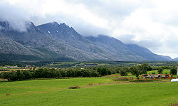
321:Lowland near the Seven Sisters mountains
316:
274:) is an island in the municipalities of
537:
422:"Stadnamn og skrivemåten for stadnamn"
442:
440:
438:
337:lie to the southwest, the islands of
478:
174:152.6 km (58.9 sq mi)
290:. The island is surrounded by the
13:
447:Thorsnæs, Geir, ed. (2018-11-14).
435:
14:
571:
490:This article about an island in
482:
88:
81:
55:
48:
414:
1:
407:
89:
56:
498:. You can help Knowledge by
7:
395:
198:1,072 m (3517 ft)
10:
576:
477:
424:(in Norwegian). Kartverket
16:Island in Nordland, Norway
402:List of islands of Norway
253:
248:
234:
224:
215:
210:
202:
194:
186:
178:
170:
133:
119:
114:
42:
33:
24:
366:Norwegian County Road 17
182:30 km (19 mi)
322:
298:to the north, and the
195:Highest elevation
69:Location of the island
560:Nordland island stubs
454:Store norske leksikon
320:
190:8 km (5 mi)
72:Show map of Nordland
555:Islands of Nordland
310:and the village of
155:65.9087°N 12.4314°E
151: /
21:
323:
203:Highest point
105:Show map of Norway
19:
507:
506:
459:Kunnskapsforlaget
294:to the east, the
261:
260:
567:
528:
521:
514:
486:
479:
469:
468:
466:
465:
457:(in Norwegian).
444:
433:
432:
430:
429:
418:
362:Helgeland Bridge
166:
165:
163:
162:
161:
160:65.9087; 12.4314
156:
152:
149:
148:
147:
144:
106:
92:
91:
85:
73:
59:
58:
52:
38:
29:
22:
18:
575:
574:
570:
569:
568:
566:
565:
564:
535:
534:
533:
532:
475:
473:
472:
463:
461:
445:
436:
427:
425:
420:
419:
415:
410:
398:
266:(historically,
220:
159:
157:
153:
150:
145:
142:
140:
138:
137:
110:
109:
108:
107:
104:
103:
100:
99:
98:
97:
93:
76:
75:
74:
71:
70:
67:
66:
65:
64:
60:
17:
12:
11:
5:
573:
563:
562:
557:
552:
547:
531:
530:
523:
516:
508:
505:
504:
487:
471:
470:
434:
412:
411:
409:
406:
405:
404:
397:
394:
314:in the south.
259:
258:
255:
251:
250:
246:
245:
236:
235:Municipalities
232:
231:
226:
222:
221:
216:
213:
212:
211:Administration
208:
207:
204:
200:
199:
196:
192:
191:
188:
184:
183:
180:
176:
175:
172:
168:
167:
135:
131:
130:
121:
117:
116:
112:
111:
102:Alsta (Norway)
101:
95:
94:
87:
86:
80:
79:
78:
77:
68:
62:
61:
54:
53:
47:
46:
45:
44:
43:
40:
39:
31:
30:
15:
9:
6:
4:
3:
2:
572:
561:
558:
556:
553:
551:
548:
546:
543:
542:
540:
529:
524:
522:
517:
515:
510:
509:
503:
501:
497:
493:
488:
485:
481:
480:
476:
460:
456:
455:
450:
443:
441:
439:
423:
417:
413:
403:
400:
399:
393:
391:
388:connects the
387:
386:Sundøy Bridge
381:
379:
375:
371:
367:
363:
358:
356:
352:
348:
344:
340:
336:
332:
328:
319:
315:
313:
309:
305:
304:Seven Sisters
301:
300:Alstenfjorden
297:
293:
289:
285:
281:
277:
273:
269:
265:
256:
252:
247:
244:
240:
237:
233:
230:
227:
223:
219:
214:
209:
205:
201:
197:
193:
189:
185:
181:
177:
173:
169:
164:
136:
132:
129:
125:
122:
118:
113:
84:
51:
41:
37:
32:
28:
23:
500:expanding it
489:
474:
462:. Retrieved
452:
426:. Retrieved
416:
382:
359:
355:Vefsnfjorden
324:
308:Sandnessjøen
292:Vefsnfjorden
271:
267:
263:
262:
257:6,969 (2017)
249:Demographics
217:
296:Leirfjorden
158: /
134:Coordinates
539:Categories
464:2019-02-23
428:2019-02-23
408:References
347:Mindlandet
254:Population
146:12°25′53″E
143:65°54′31″N
550:Leirfjord
545:Alstahaug
374:Offersøya
370:Leirfjord
343:Offersøya
327:Botnkrona
280:Leirfjord
276:Alstahaug
243:Leirfjord
239:Alstahaug
206:Botnkrona
115:Geography
492:Nordland
396:See also
286:county,
284:Nordland
229:Nordland
124:Nordland
120:Location
449:"Alsta"
335:Skålvær
272:Alstein
390:Sundøy
378:Tjøtta
351:Rødøya
349:, and
339:Tjøtta
312:Søvika
288:Norway
268:Alsten
225:County
218:Norway
179:Length
128:Norway
494:is a
331:Altra
264:Alsta
187:Width
96:Alsta
63:Alsta
20:Alsta
496:stub
380:.
376:and
333:and
278:and
241:and
171:Area
364:on
282:in
270:or
541::
451:.
437:^
357:.
345:,
341:,
126:,
527:e
520:t
513:v
502:.
467:.
431:.
Text is available under the Creative Commons Attribution-ShareAlike License. Additional terms may apply.


