216:
248:
911:
200:
918:
255:
223:
789:
958:
938:
31:
537:
The airport upgraded the lighting and signs on the runway and taxiways to LED in 2018/2019. A project to add a 900 ft (270 m) extension to the northeast end of the runway (lengthening the runway to 8,000 ft (2,400 m) total) is planned to begin in 2023, with construction beginning
530:
In 2013, the airport began construction on a two-story, 67,000 sq ft (6,200 m) replacement passenger terminal building. The new terminal features passenger loading bridges, new concessions, expanded passenger areas and space for additional airlines. This is part of the airport's $
526:
The airport is served by a fixed-base operator, Skyport
Aviation, which offers fueling, maintenance, flight instruction and aircraft rentals from the new 10,000-ft executive terminal, which opened in 2015.
1409:
480:, starting on December 11, 2006. Delta began operating B-717 aircraft on the OAJ-ATL route on August 28, 2016. When ExpressJet closed, the service transferred to Endeavor Airlines.
1308:
531:
50-million
Terminal Area Redevelopment Program. The new terminal was topped off on June 10, 2014, and officially opened on August 19, 2015, National Aviation Day.
1414:
946:
889:
877:
145:
1301:
1224:
1210:
767:
534:
On
December 6, 2017, the airport began construction on its first air traffic control tower. The six-story-tall tower opened on November 1, 2018.
1294:
910:
1088:
1376:
810:
1128:
215:
1334:
967:
865:
754:
446:
1352:
247:
1404:
1155:
1317:
999:
538:
in 2025. Other projects to rehabilitate and expand airfield pavements are also planned to begin between 2023 and 2027.
507:
For the 12-month period ending May 31, 2020, the airport had 29,544 aircraft operations, an average of 81 per day: 35%
1114:
1370:
836:
523:. In December 2020, there were 26 aircraft based at this airport: 22 single-engine, 1 multi-engine and 3 helicopter.
818:
1382:
1340:
1151:
392:
362:
64:
1234:
979:
860:
814:
435:
423:
1346:
407:
98:
419:
138:
108:
1358:
199:
1195:
67:
1328:
415:
411:
120:
1031:
1027:
799:
454:
1246:
803:
128:
8:
395:
1286:
1262:
462:
508:
458:
384:
376:
53:
42:
1218:
884:
512:
501:
473:
439:
431:
1266:
1252:
1180:
872:
469:
493:
30:
1398:
160:
147:
1272:
1256:
450:
1089:"Albert J. Ellis Airport breaks ground on new air traffic control tower"
488:
Albert J. Ellis
Airport covers an area of 775 acres (314 ha) at an
477:
430:
and three gates. Opening on
February 15, 1971, the airport is used by
292:
1240:
489:
1276:
788:
520:
516:
403:
497:
427:
279:
1035:. Federal Aviation Administration. effective December 3, 2020.
1204:
504:
surface measuring 7,100 by 150 ft (2,164 by 46 m).
1214:
1410:
Buildings and structures in Onslow County, North
Carolina
1316:
1186:
1047:
181:
1064:
1062:
1060:
1058:
1056:
1053:
414:, 10 nautical miles (19 km) northwest of the
1115:"New airport tower to improve safety, efficiency"
1396:
1415:Transportation in Onslow County, North Carolina
1302:
778:
434:, the military and two commercial airlines,
1141:Preliminary - Albert J. Ellis Airport Stats
817:. Unsourced material may be challenged and
726:
1309:
1295:
1129:"State Transportation Improvement Program"
483:
472:announced new service from the airport to
1043:
1041:
983:Destinations from Albert J. Ellis Airport
837:Learn how and when to remove this message
1144:
1335:Charlotte Douglas International Airport
541:
476:, operated by Delta Connection carrier
1397:
1038:
1318:Commercial airports in North Carolina
1290:
1023:
1021:
1019:
1017:
1015:
1377:Raleigh–Durham International Airport
1353:Piedmont Triad International Airport
917:
815:adding citations to reliable sources
782:
445:American Eagle operates services to
1156:Bureau of Transportation Statistics
13:
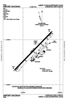
1152:"RITA | BTS | Transtats"
1012:
1000:List of airports in North Carolina
410:, United States. It is located in
14:
1426:
1371:Coastal Carolina Regional Airport
1174:
957:
449:. These services are operated by
1383:Wilmington International Airport
1341:Concord-Padgett Regional Airport
956:
936:
916:
909:
787:
492:of 94 ft (29 m) above
253:
246:
221:
214:
198:
29:
1261:NOAA/NWS weather observations:
1225:FAA Terminal Procedures for OAJ
1086:
937:
730:
402:) is a county-owned public-use
16:Airport in North Carolina, U.S.
1135:
1121:
1107:
1080:
1071:
424:Marine Corps Base Camp Lejeune
204:FAA diagram as of January 2021
1:
1347:Fayetteville Regional Airport
1227:, effective September 5, 2024
1211:Aerial image as of March 1993
1191:, effective September 5, 2024
1028:FAA Airport Form 5010 for OAJ
1005:
734:November 2021 – October 2022)
408:Onslow County, North Carolina
269:Show map of the United States
118:264 Albert Ellis Airport Road
1241:airport information for KOAJ
1230:Resources for this airport:
109:Jacksonville, North Carolina
7:
1235:airport information for OAJ
1095:. Nexstar Broadcasting, Inc
993:
426:. The airport has a single
254:
222:
10:
1431:
1405:Airports in North Carolina
1329:Asheville Regional Airport
340:Aircraft operations (2020)
237:Show map of North Carolina
1324:
1196:"Albert J. Ellis Airport"
779:Airlines and destinations
755:Charlotte, North Carolina
732:Busiest domestic routes (
416:central business district
359:
347:
339:
335:
330:
299:
296:
291:
287:
278:
208:
197:
192:
176:
137:
126:
121:Richlands, North Carolina
114:
104:
94:
86:
81:
37:
28:
21:
1247:accident history for OAJ
727:Top nonstop destinations
500:designated 5/23 with an
1365:Albert J. Ellis Airport
1359:Pitt–Greenville Airport
1048:Albert J. Ellis Airport
484:Facilities and aircraft
373:Albert J. Ellis Airport
23:Albert J. Ellis Airport
133:94 ft / 29 m
455:CRJ-700s and CRJ-900s
348:Based aircraft (2020)
161:34.82917°N 77.61222°W
1068:OAJ Airport Director
980:class=notpageimage|
811:improve this section
542:Passenger statistics
517:scheduled commercial
468:On August 30, 2006,
1277:Terminal Procedures
1257:live flight tracker
1253:airport information
1181:FAA Airport Diagram
736:
478:ExpressJet Airlines
365:and airport website
166:34.82917; -77.61222
157: /
1273:aeronautical chart
731:
1392:
1391:
1207:airport directory
1034:
991:
990:
972:
949:
929:
900:Destinations map
895:
894:
847:
846:
839:
776:
775:
724:
723:
461:, which operates
459:Piedmont Airlines
453:, which operates
370:
369:
355:
354:
326:
325:
1422:
1311:
1304:
1297:
1288:
1287:
1219:The National Map
1202:
1200:
1190:
1168:
1167:
1165:
1163:
1148:
1142:
1139:
1133:
1132:
1125:
1119:
1118:
1111:
1105:
1104:
1102:
1100:
1087:Tew, Elizabeth.
1084:
1078:
1075:
1069:
1066:
1051:
1045:
1036:
1030:
1025:
970:
964:
960:
959:
945:
940:
939:
925:
920:
919:
913:
897:
896:
885:Delta Connection
849:
848:
842:
835:
831:
828:
822:
791:
783:
768:Atlanta, Georgia
737:
546:
545:
513:general aviation
474:Atlanta, Georgia
440:Delta Connection
432:general aviation
337:
336:
289:
288:
282:
270:
257:
256:
250:
238:
225:
224:
218:
202:
188:
185:
183:
172:
171:
169:
168:
167:
162:
158:
155:
154:
153:
150:
74:
73:
60:
59:
49:
48:
33:
19:
18:
1430:
1429:
1425:
1424:
1423:
1421:
1420:
1419:
1395:
1394:
1393:
1388:
1320:
1315:
1284:
1267:past three days
1198:
1194:
1184:
1177:
1172:
1171:
1161:
1159:
1150:
1149:
1145:
1140:
1136:
1127:
1126:
1122:
1113:
1112:
1108:
1098:
1096:
1085:
1081:
1077:FAA 5010 Record
1076:
1072:
1067:
1054:
1050:, official site
1046:
1039:
1026:
1013:
1008:
996:
987:
986:
985:
984:
982:
976:
975:
974:
973:
966:
961:
953:
952:
951:
941:
933:
932:
931:
930:
921:
873:Delta Air Lines
843:
832:
826:
823:
808:
792:
781:
729:
544:
486:
470:Delta Air Lines
366:
280:
274:
273:
272:
271:
268:
267:
266:
265:
264:
258:
241:
240:
239:
236:
235:
234:
233:
232:
226:
203:
180:
165:
163:
159:
156:
151:
148:
146:
144:
143:
127:Elevation
119:
77:
71:
63:
57:
52:
46:
41:
24:
17:
12:
11:
5:
1428:
1418:
1417:
1412:
1407:
1390:
1389:
1387:
1386:
1380:
1374:
1368:
1367:(Jacksonville)
1362:
1356:
1350:
1349:(Fayetteville)
1344:
1338:
1332:
1325:
1322:
1321:
1314:
1313:
1306:
1299:
1291:
1282:
1281:
1280:
1279:
1269:
1259:
1249:
1243:
1237:
1228:
1222:
1208:
1192:
1176:
1175:External links
1173:
1170:
1169:
1158:. January 2017
1143:
1134:
1120:
1106:
1079:
1070:
1052:
1037:
1010:
1009:
1007:
1004:
1003:
1002:
995:
992:
989:
988:
978:
977:
963:
962:
955:
954:
943:
942:
935:
934:
924:
923:
922:
915:
914:
908:
907:
906:
905:
902:
901:
893:
892:
887:
881:
880:
875:
869:
868:
863:
861:American Eagle
857:
856:
853:
845:
844:
795:
793:
786:
780:
777:
774:
773:
770:
765:
761:
760:
757:
752:
748:
747:
744:
741:
728:
725:
722:
721:
718:
714:
713:
710:
706:
705:
702:
698:
697:
694:
690:
689:
686:
682:
681:
678:
674:
673:
670:
666:
665:
662:
658:
657:
654:
650:
649:
646:
642:
641:
638:
634:
633:
630:
626:
625:
622:
618:
617:
614:
610:
609:
606:
602:
601:
598:
594:
593:
590:
586:
585:
582:
578:
577:
574:
570:
569:
566:
562:
561:
558:
554:
553:
550:
543:
540:
494:mean sea level
485:
482:
436:American Eagle
368:
367:
360:
357:
356:
353:
352:
349:
345:
344:
341:
333:
332:
328:
327:
324:
323:
320:
317:
314:
310:
309:
306:
302:
301:
298:
295:
285:
284:
276:
275:
260:
259:
252:
251:
245:
244:
243:
242:
228:
227:
220:
219:
213:
212:
211:
210:
209:
206:
205:
195:
194:
190:
189:
178:
174:
173:
141:
135:
134:
131:
124:
123:
116:
112:
111:
106:
102:
101:
96:
92:
91:
88:
84:
83:
79:
78:
76:
75:
61:
50:
38:
35:
34:
26:
25:
22:
15:
9:
6:
4:
3:
2:
1427:
1416:
1413:
1411:
1408:
1406:
1403:
1402:
1400:
1384:
1381:
1378:
1375:
1372:
1369:
1366:
1363:
1360:
1357:
1354:
1351:
1348:
1345:
1342:
1339:
1336:
1333:
1330:
1327:
1326:
1323:
1319:
1312:
1307:
1305:
1300:
1298:
1293:
1292:
1289:
1285:
1278:
1274:
1270:
1268:
1264:
1260:
1258:
1254:
1250:
1248:
1244:
1242:
1238:
1236:
1232:
1231:
1229:
1226:
1223:
1221:
1220:
1216:
1212:
1209:
1206:
1197:
1193:
1188:
1182:
1179:
1178:
1157:
1153:
1147:
1138:
1130:
1124:
1116:
1110:
1094:
1090:
1083:
1074:
1065:
1063:
1061:
1059:
1057:
1049:
1044:
1042:
1033:
1029:
1024:
1022:
1020:
1018:
1016:
1011:
1001:
998:
997:
981:
971:
969:
950:
948:
928:
912:
904:
903:
899:
898:
891:
888:
886:
883:
882:
879:
876:
874:
871:
870:
867:
864:
862:
859:
858:
854:
851:
850:
841:
838:
830:
820:
816:
812:
806:
805:
801:
796:This section
794:
790:
785:
784:
771:
769:
766:
763:
762:
758:
756:
753:
750:
749:
745:
742:
739:
738:
735:
719:
716:
715:
711:
708:
707:
703:
700:
699:
695:
692:
691:
687:
684:
683:
679:
676:
675:
671:
668:
667:
663:
660:
659:
655:
652:
651:
647:
644:
643:
639:
636:
635:
631:
628:
627:
623:
620:
619:
615:
612:
611:
607:
604:
603:
599:
596:
595:
591:
588:
587:
583:
580:
579:
575:
572:
571:
567:
564:
563:
559:
556:
555:
551:
548:
547:
539:
535:
532:
528:
524:
522:
518:
514:
510:
505:
503:
499:
496:. It has one
495:
491:
481:
479:
475:
471:
466:
464:
460:
456:
452:
448:
443:
441:
437:
433:
429:
425:
421:
417:
413:
409:
405:
401:
397:
394:
390:
386:
382:
378:
374:
364:
358:
350:
346:
342:
338:
334:
329:
321:
318:
315:
312:
311:
307:
304:
303:
294:
290:
286:
283:
277:
263:
249:
231:
217:
207:
201:
196:
191:
187:
179:
175:
170:
142:
140:
136:
132:
130:
125:
122:
117:
113:
110:
107:
103:
100:
99:Onslow County
97:
93:
89:
85:
80:
69:
66:
62:
55:
51:
44:
40:
39:
36:
32:
27:
20:
1385:(Wilmington)
1364:
1361:(Greenville)
1355:(Greensboro)
1283:
1251:FlightAware
1217:
1160:. Retrieved
1146:
1137:
1123:
1109:
1097:. Retrieved
1092:
1082:
1073:
965:
944:
927:Jacksonville
926:
855:Destinations
833:
827:January 2022
824:
809:Please help
797:
733:
536:
533:
529:
525:
506:
487:
467:
451:PSA Airlines
444:
420:Jacksonville
399:
388:
380:
372:
371:
261:
229:
87:Airport type
1337:(Charlotte)
1331:(Asheville)
746:Passengers
552:Passengers
164: /
152:077°36′44″W
139:Coordinates
1399:Categories
1373:(New Bern)
1271:SkyVector
1099:20 January
1006:References
331:Statistics
149:34°49′45″N
1379:(Raleigh)
1343:(Concord)
968:Charlotte
866:Charlotte
798:does not
490:elevation
447:Charlotte
412:Richlands
361:Sources:
293:Direction
1093:wcnt.com
994:See also
852:Airlines
688:151,257
680:191,194
672:179,878
664:242,817
656:262,178
648:249,563
640:314,883
632:344,467
624:352,455
616:344,710
608:321,642
600:302,608
592:303,288
584:313,940
576:308,553
568:332,270
560:212,444
521:air taxi
509:military
463:ERJ-145s
322:Asphalt
300:Surface
115:Location
1263:current
1239:AirNav
1162:May 15,
947:Atlanta
890:Atlanta
878:Atlanta
819:removed
804:sources
772:59,000
759:88,000
720:77,342
712:62,454
704:65,210
696:87,814
519:and 9%
502:asphalt
404:airport
297:Length
281:Runways
184:.flyoaj
177:Website
82:Summary
1183:
515:, 23%
511:, 33%
498:runway
457:, and
428:runway
343:29,544
319:2,164
316:7,100
105:Serves
90:Public
1213:from
1205:NCDOT
1199:(PDF)
743:City
740:Rank
313:5/23
95:Owner
1255:and
1245:ASN
1233:FAA
1215:USGS
1164:2017
1101:2018
802:any
800:cite
717:2000
709:2001
701:2002
693:2003
685:2004
677:2005
669:2006
661:2007
653:2008
645:2009
637:2010
629:2011
621:2012
613:2013
605:2014
597:2015
589:2016
581:2017
573:2018
565:2019
557:2020
549:Year
438:and
422:and
389:KOAJ
385:ICAO
377:IATA
193:Maps
186:.com
129:AMSL
58:KOAJ
54:ICAO
43:IATA
1203:at
1187:PDF
1032:PDF
813:by
418:of
406:in
400:OAJ
396:LID
393:FAA
381:OAJ
363:FAA
305:ft
262:OAJ
230:OAJ
182:www
72:OAJ
68:LID
65:FAA
47:OAJ
1401::
1275:,
1265:,
1154:.
1091:.
1055:^
1040:^
1014:^
764:2
751:1
465:.
442:.
398::
391:,
387::
383:,
379::
351:26
308:m
70::
56::
45::
1310:e
1303:t
1296:v
1201:.
1189:)
1185:(
1166:.
1131:.
1117:.
1103:.
840:)
834:(
829:)
825:(
821:.
807:.
375:(
Text is available under the Creative Commons Attribution-ShareAlike License. Additional terms may apply.